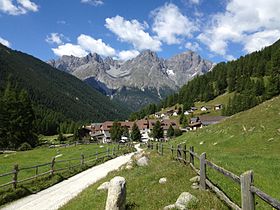
Val S-charl
| S-charl | ||
|---|---|---|
| State : |
|
|
| Canton : |
|
|
| Region : | Inn | |
| Political community : | Scuol | |
| Postal code : | 7550 | |
| former BFS no. : | 3762 | |
| Coordinates : | 821 384 / 177 903 | |
| Height : | 1810 m above sea level M. | |
| Website: | www.scuol.net | |
|
S-charl and the Val S-charl, |
||
| map | ||
|
|
||
S-charl is a summer village located at 1800 meters in the municipality of Scuol . The former miners' settlement gives the Val S-charl ( ), a side valley of the Lower Engadine , its name.
geography

S-charl is on the way from Scuol over the Pass da Costainas and Lü into Val Müstair and into Vinschgau .
The main river of Val S-charl is the Clemgia , which rises at the upper end of the valley not far from the pass near the border with Italian South Tyrol . Tamangur , the highest pine forest in Europe, is located above the 13 houses . Below S-charls, the Clemgia flows through the wild Clemgiaschlucht and flows into the Inn at Scuol. The lower left half of the valley is part of the Swiss National Park .
history
The name «Scharles» appears as early as 1095. The Lords of Tarasp donated goods to the Scuol Monastery in the 11th and 12th centuries in S-charl. The chapel probably dates from the same time. In 1499 and 1621 the settlement was burned down. In the 16th century there were 70 houses in S-charl, and around 1825 there was even a school (which was also attended by children from Scuol because they could learn German there). The faction was inhabited all year round until 1950. In 1904, the last brown bear in Switzerland was shot here.
For centuries, mining was important for S-charl and the adjacent Val Mingèr . From 1317 to 1652 and then again in the first half of the 19th century, silver and lead ore were mined. The silver mine was loaned to various Engadine families in 1317, and in 1356 it went to the von Planta von Zuoz family . Until the Lower Engadine was bought out in 1652, the royal mining shelves were held by the Counts of Tyrol and the rule of Austria . Lead and silver mining came to a standstill in the 17th century. From 1819 to 1829 the plant was operated by Johann Hitz from Klosters . From 1823 to 1828 8,060 kg of lead and 200 kg of silver were extracted. The Knappenhaus and the so-called Schmelzra also date from this time . In the middle of the 19th century the mining operations were finally stopped. The ruins of the Schmelzra, renovated in 1989 and today a mining and bear museum of the national park, are a reminder of the mining operations.
Sights, economy and infrastructure
In S-charl there is a listed reformed church that is used in summer for Sunday services and wedding celebrations.
The Scuol Alps, which have been important for centuries, are also located in Val S-charl. Tourism is also very important in S-charl today (hiking and biking in summer, ski touring in winter). In summer S-charl can be reached by a post bus line, in winter by horse-drawn sleigh.
literature
- Peter Abt, S-charl, a former mining settlement in the Lower Engadine , Geographica Helvetica, Volume 28, 1973, pp. 159–163, doi: 10.5194 / gh-28-159-1973
Web links
swell
- ↑ Handbook of the Swiss Alps, Haupt Verlag 2008
- ^ Paul Eugen Grimm: S-charl. In: Historical Lexicon of Switzerland .


