Ambo District
| Ambo District | |
|---|---|
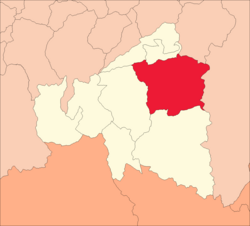
 Location of the district in Ambo Province |
|
| Basic data | |
| Country | Peru |
| region | Huánuco |
| province | Ambo |
| Seat | Ambo |
| surface | 288.8 km² |
| Residents | 20,886 (2017) |
| density | 72 inhabitants per km² |
| founding | October 21, 1912 |
| ISO 3166-2 | PE-HUC |
| Website | muniambo.gob.pe (Spanish) |
| politics | |
| Alcalde Provincial | David Antonio Herrera Yumpe (2019-2022) |
| Political party | Avanza País - Partido de Integración Social. |
Coordinates: 10 ° 8 ′ S , 76 ° 12 ′ W
The district of Ambo is located in the province of Ambo in the Huánuco region in central Peru . The district was established on October 21, 1912. It has an area of 288.8 km². The 2017 census counted 20,886 inhabitants. In 1993 the population was 13,833, in 2007 15,745. The administrative seat of the district is the provincial capital Ambo . This is located at the confluence of the Río Huertas in the Río Huallaga 22 km south of the regional capital Huánuco .
Geographical location
The district of Ambo is located in the Peruvian Central Cordillera in the central northeast of the province of Ambo. The Río Huallaga flows through the district in a northerly direction.
The district of Ambo is bordered to the west by the district of Huácar , to the north by the districts of Conchamarca and Tomaykichwa , to the east by the districts of Molino and Panao (both in the province of Pachitea ) and to the south by the district of San Rafael .
Individual evidence
- ↑ a b PERU: Huánuco region - provinces and districts . www.citypopulation.de. Retrieved February 20, 2020.