Chocope District
| Chocope District | ||
|---|---|---|
 The district of Chocope is centrally located in the province of Ascope (marked in red) |
||
| Symbols | ||
|
||
| Basic data | ||
| Country | Peru | |
| region | La Libertad | |
| province | Ascope | |
| Seat | Chocope | |
| surface | 100.2 km² | |
| Residents | 9321 (2017) | |
| density | 93 inhabitants per km² | |
| ISO 3166-2 | PE-LAL | |
| Website | munichocope.gob.pe (Spanish) | |
| politics | ||
| Alcalde District | Carlos Alza Moncada (2019-2022) |
|
| Political party | Alianza Popular Revolucionaria Americana | |
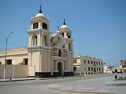
| Church and Carmelite Convent in Chocope | ||
Coordinates: 7 ° 47 ′ S , 79 ° 13 ′ W
The Chocope district is located in the Ascope province in the La Libertad region in northwestern Peru . The 100.24 km² district had 9321 inhabitants at the 2017 census. In 2007 the population was 10,138. The administrative seat is the 109 m high town of Chocope . The Chicama River flows southwest along the southeastern district boundary . Irrigated agriculture is used. The national road 1N ( Panamericana ) leads from Trujillo past Chocope to the north.
Geographical location
The district of Chocope is centrally located in the Ascope province in the coastal lowlands on the north bank of the Río Chicama. The Chocope district borders in the southwest on the Magdalena de Cao district , in the west on the Paiján district , in the north on the Casa Grande district and in the east on the Chicama district .
Web links
- Municipalidad Distrital de Chocope
- Peru: Region La Libertad (provinces and districts) at www.citypopulation.de
- INEI Perú

