Casa Grande district
| Casa Grande district | |
|---|---|
 The Casa Grande district is located in the central north of the Ascope province (marked in red) |
|
| Basic data | |
| Country | Peru |
| region | La Libertad |
| province | Ascope |
| Seat | Casa Grande |
| surface | 677.2 km² |
| Residents | 28,492 (2017) |
| density | 42 inhabitants per km² |
| founding | January 21, 1998 |
| ISO 3166-2 | PE-LAL |
| Website | www.municasagrande.gob.pe (Spanish) |
| politics | |
| Alcalde District | Juan Francisco Fernández Gallardo (2019-2022) |
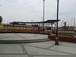
| Plaza de Armas in Casa Grande | |
Coordinates: 7 ° 45 ′ S , 79 ° 11 ′ W
The Casa Grande district is located in the Ascope province in the La Libertad region in northwestern Peru . The district was created on January 21, 1998 from parts of the Ascope and Chocope districts . The district of 677.17 km² had 28,492 inhabitants at the 2017 census. Ten years earlier the population was 29,884. The administrative seat is the 147 m high town of Casa Grande . There is also the small town of Roma on the north bank of the Río Chicama . The Chicama River flows along the southern district boundary. Irrigated agriculture is practiced in the lowlands. On the slopes of the up to 2000 m high Peruvian Western Cordillera and in the north of the district there is desert vegetation.
Geographical location
The Casa Grande district is located in the central north of the Ascope province. The Pacific coast is about 20 km to the west. The Casa Grande district borders in the northwest with the district San Pedro de Lloc ( Pacasmayo province ), in the northeast with the districts Cupisnique and San Benito (both in the province Contumazá ), in the east with the district Ascope , in the southeast with the district Chicama , to the south to the Chocope district and to the west to the Paiján and Rázuri districts .
Web links
- Municipalidad de Casa Grande
- Peru: Region La Libertad (provinces and districts) at www.citypopulation.de
- INEI Perú
