Paiján District
| Paiján District | |
|---|---|
 The district of Paiján is located in the central northwest of the province Ascope (marked in red) |
|
| Basic data | |
| Country | Peru |
| region | La Libertad |
| province | Ascope |
| Seat | Paijan |
| surface | 79.3 km² |
| Residents | 25,913 (2017) |
| density | 327 inhabitants per km² |
| founding | November 10, 1900 |
| ISO 3166-2 | PE-LAL |
| Website | www.munipaijan.gob.pe (Spanish) |
| politics | |
| Alcalde District | Oswaldo Daniel Alva Iglesias (2019-2022) |
| Political party | Partido Democrático Somos Perú |
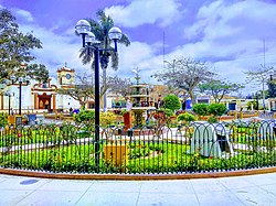
| Plaza de Armas in Paiján | |
Coordinates: 7 ° 44 ′ 3 ″ S , 79 ° 18 ′ 12 ″ W.
The district of Paiján is located in the province of Ascope in the La Libertad region in northwestern Peru . The 79.32 km² district had 25,913 inhabitants at the 2017 census. In 1993 the population was 19,133, in 2007 23,194. The administrative seat is the 80 m high city of Paiján . The district is located in the coastal lowlands north of the Río Chicama. It reaches up to almost 7 km from the Pacific coast . Irrigated agriculture is used. The national road 1N ( Panamericana ) leads from Trujillo past Paiján to the north.
Geographical location
The Paiján District is located in the central northwest of the Ascope Province. The Paijan district is bordered to the west and north by the district Rázuri , on the east by the district Casa Grande , in the southeast of the district Chocope and the south by the district Magdalena de Cao .
Web links
- Municipalidad Distrital de Paiján
- Peru: Region La Libertad (provinces and districts) at www.citypopulation.de
- INEI Perú
