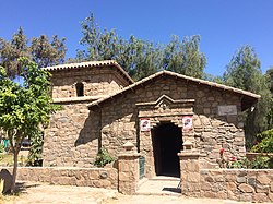
Santa Rosa de Quives district
| Santa Rosa de Quives district | |||
|---|---|---|---|
 The district of Santa Rosa de Quives is located in the southwest of the province of Canta (marked in red) |
|||
| Symbols | |||
|
|||
| Basic data | |||
| Country | Peru | ||
| region | Lima | ||
| province | Canta | ||
| Seat | Yangas | ||
| surface | 364 km² | ||
| Residents | 6298 (2017) | ||
| density | 17 inhabitants per km² | ||
| founding | January 16, 1952 | ||
| ISO 3166-2 | PE-LIM | ||
| politics | |||
| Alcalde District | Alfredo Solis Huaman | ||
Coordinates: 11 ° 40 ′ S , 76 ° 47 ′ W
The Santa Rosa de Quives District is one of seven districts of the province of Canta in the region of Lima in Peru . In 2017, 6,298 people lived on an area of 364 km². In 1993 the population was 3007, in 2007 6173. On January 16, 1952, Santa Rosa de Quives was officially a district. The administrative center is 940 m high Yangas with 468 inhabitants (as of 2017).
Geographical location
Santa Rosa de Quives borders in the north on the district of Huamantanga , in the east on the districts of Lachaqui and Arahuay , in the south on the province of Huarochirí and in the south and west on the district of Carabayllo .
Festivals
Web links
Commons : Santa Rosa de Quives district - collection of images, videos and audio files
- Peru: Region Lima (provinces and districts) at www.citypopulation.de
- Tour info


