Carabayllo district
| Carabayllo district | |||
|---|---|---|---|
 Location of the district in the province of Lima |
|||
| Symbols | |||
|
|||
| Basic data | |||
| Country | Peru | ||
| region | region free | ||
| province | Lima | ||
| Seat | San Pedro de Carabayllo | ||
| surface | 346.9 km² | ||
| Residents | 333,045 (2017) | ||
| density | 960 inhabitants per km² | ||
| founding | January 2, 1857 | ||
| ISO 3166-2 | PE | ||
| politics | |||
| Alcalde District | Marcos Lorenzo Espinoza Ortiz (2019-2022) |
||
| Political party | Alianza para el Progreso | ||
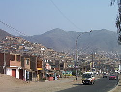
| Carabayllo, Av. Túpac Amaru | |||
Coordinates: 11 ° 53 ′ S , 77 ° 2 ′ W
The Carabayllo District is one of the 43 municipalities in the Lima Metropolitana Region in Peru . It has an area of 346.89 km². The 2017 census counted 333,045 inhabitants. In 1993 the population was 106,543, in 2007 213,386. The administrative seat is in San Pedro de Carabayllo.
Geographical location
The Carabayllo district is in the north of the Lima Province . It is located on the edge of the Peruvian Western Cordillera 20 km north of Lima city center . The mountains reach heights of up to 2556 m in the northeast . The river Río Chillón flows through the district in a southerly direction.
The Carabayllo district borders in the northwest on the Ancón district , in the northeast on the districts Huamantanga and Santa Rosa de Quives (both in the province of Canta ), in the southeast on the districts of San Antonio ( province Huarochirí ) and San Juan de Lurigancho , in the southwest the Comas district and to the west to the Puente Piedra district .
Web links
- Peru: Region Lima (provinces and districts) at www.citypopulation.de


