San Juan de Miraflores district
| San Juan de Miraflores district | |||
|---|---|---|---|
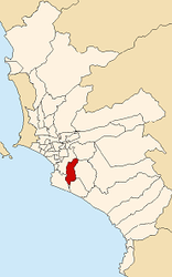
 Location of the district in the province of Lima |
|||
| Symbols | |||
|
|||
| Basic data | |||
| Country | Peru | ||
| region | region free | ||
| province | Lima | ||
| surface | 24 km² | ||
| Residents | 355,219 (2017) | ||
| density | 14,813 inhabitants per km² | ||
| founding | January 12, 1965 | ||
| ISO 3166-2 | PE | ||
| Website | www.munisjm.gob.pe (Spanish) | ||
| politics | |||
| Alcaldesa district | María Cristina Nina Garnica (2019-2022) |
||
| Political party | Acción Popular | ||
Coordinates: 12 ° 9 ′ 48 ″ S , 76 ° 57 ′ 49 ″ W.
The district of San Juan de Miraflores is one of the 43 municipalities of the Lima Metropolitana region in Peru . It covers an area of 23.98 km². The 2017 census counted 355,219 inhabitants. In 1993 the population was 283,349, in 2007 it was 362,643. The district was established on January 12, 1965. It is divided into 6 zones: Pamplona Alta, Pamplona Baja, Zona Urbana, María Auxiliadora, Pampas de San Juan and Panamericana Sur.
Geographical location
The district of San Juan de Miraflores is located 15 km south-southeast of the city center of Lima at an altitude of about 140 m . The district has a longitudinal extension in SSW-NNE direction of 9.2 km and a maximum width of 4.5 km. The national road 1S ( Panamericana ) crosses the extreme west of the district in a southern direction. The district of San Juan de Miraflores borders in the west with the district Santiago de Surco , in the north with the district La Molina , in the east with the district Villa María del Triunfo and in the south with the districts Villa El Salvador and Chorrillos .
Web links
- Municipalidad de San Juan de Miraflores
- Peru: Region Lima (provinces and districts) at www.citypopulation.de


