Pachacámac district
| Pachacámac district | |
|---|---|
 Location of the district in the province of Lima |
|
| Basic data | |
| Country | Peru |
| region | region free |
| province | Lima |
| Seat | Pachacámac |
| surface | 160.2 km² |
| Residents | 110,071 (2017) |
| density | 687 inhabitants per km² |
| founding | January 2, 1857 |
| ISO 3166-2 | PE |
| Website | www.munipachacamac.gob.pe (Spanish) |
| politics | |
| Alcalde District | Guillermo Elvis Pómez Cano (2019-2022) |
| Political party | Partido Democrático Somos Perú |
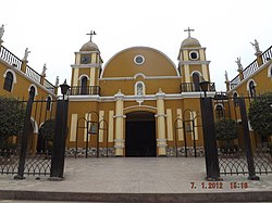
| Iglesia Matriz de Pachacámac | |
Coordinates: 12 ° 14 ′ S , 76 ° 52 ′ W
The district of Pachacámac is one of the 43 municipalities of the Lima Metropolitana region in Peru . It has an area of 160.23 km². The 2017 census counted 110,071 inhabitants. In 1993 the population was 19,850, in 2007 it was 68,441. The administrative seat is in Pachacámac . The eponymous ruined city of Pachacámac is located in the neighboring district of Lurín .
Geographical location
The Pachacámac district is located in the south of the Lima province . It lies on the lower reaches of the Río Lurín and extends up to 5 km to the Pacific coast . The foothills of the Peruvian Western Cordillera rise on both sides of the river valley . Irrigated agriculture is practiced in the lowlands.
The Pachacámac district is bordered by the Villa María del Triunfo and La Molina districts to the west, the Cieneguilla district to the north, the Antioquía and Santo Domingo de los Olleros districts to the east (both in the Huarochirí province ) and the Lurín district to the south .
Web links
- Municipalidad de Pachacámac
- Peru: Region Lima (provinces and districts) at www.citypopulation.de
