Punta Negra district
| Punta Negra district | |
|---|---|
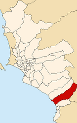
 Location of the district in the province of Lima |
|
| Basic data | |
| Country | Peru |
| region | region free |
| province | Lima |
| Seat | Punta Negra |
| surface | 130.5 km² |
| Residents | 7074 (2017) |
| density | 54 inhabitants per km² |
| founding | April 7, 1954 |
| ISO 3166-2 | PE |
| Website | www.munipuntanegra.gob.pe (Spanish) |
| politics | |
| Alcalde District | José Ruben Delgado Heredia (2019-2022) |
| Political party | Partido Popular Cristiano |
Coordinates: 12 ° 22 ′ S , 76 ° 48 ′ W
The Punta Negra district is one of the 43 urban districts of the Lima Metropolitana region in Peru . It has an area of 130.5 km². The 2017 census counted 7,074 inhabitants. In 1993 the population was 2373, in 2007 it was 5284. The administrative center is Punta Negra .
Geographical location
The Punta Negra district is located in the south of the Lima Province , 44 km southeast of Lima city center . The district has an approximately 6 km long section on the Pacific coast and extends almost 25 km inland, where the foothills of the Peruvian Western Cordillera rise. The district borders in the north on the district Punta Hermosa , in the east on the district Santo Domingo de los Olleros ( province Huarochirí ) and in the south on the district San Bartolo .
Web links
- Municipalidad Distrital de Punta Negra
- Peru: Region Lima (provinces and districts) at www.citypopulation.de