San Borja District
| San Borja District | |||
|---|---|---|---|
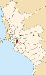
 Location of the district in the province of Lima |
|||
| Symbols | |||
|
|||
| Basic data | |||
| Country | Peru | ||
| region | region free | ||
| province | Lima | ||
| surface | 10 km² | ||
| Residents | 113,247 (2017) | ||
| density | 11,370 inhabitants per km² | ||
| founding | June 1, 1983 | ||
| ISO 3166-2 | PE | ||
| Website | www.munisanborja.gob.pe (Spanish) | ||
| politics | |||
| Alcalde District | Carlos Alberto Tejada Noriega (2019-2022) |
||
| Political party | Acción Popular | ||
| Limatambo in San Borja | |||
Coordinates: 12 ° 6 ′ 26 ″ S , 76 ° 59 ′ 57 ″ W.
The district of San Borja is one of the 43 municipalities of the Lima Metropolitana region in Peru . It has an area of 9.96 km². The 2017 census counted 113,247 inhabitants. In 1993 the population was 99,947, in 2007 105,076. The district was established on June 1, 1983.
Geographical location
The district of San Borja is located 7.6 km south-southeast of the city center of Lima at an altitude of about 170 m . The district has an approximately rectangular shape with 3.4 km in an east-west direction and 3. km in a north-south direction. The national road 1S ( Panamericana ) runs along the eastern district border. The southern district boundary is Avenida Angamos, the western district boundary is Avenida Miguel Iglesias and the northern district boundary is Avenida Canada. The district of San Borja is bordered by the district of San Isidro to the west, by the districts of San Luis , La Victoria and Ate to the north, by the district of Santiago de Surco to the east and southeast and by the district of Surquillo to the southwest .
Web links
- Municipalidad de San Borja
- Peru: Region Lima (provinces and districts) at www.citypopulation.de


