Yauya District
| Yauya District | |
|---|---|
 The district of Yauya is located in the northwest of the province of Carlos Fermín Fitzcarrald (marked in red) |
|
| Basic data | |
| Country | Peru |
| region | Ancash |
| province | Carlos Fermín Fitzcarrald |
| Seat | Yauya |
| surface | 175 km² |
| Residents | 4336 (2017) |
| density | 25 inhabitants per km² |
| founding | November 18, 1905 |
| ISO 3166-2 | PE-ANC |
| politics | |
| Alcalde District | Jesus Mateo Gomero Camones (2019-2022) |
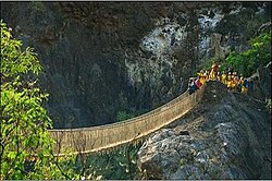
| Pedestrian suspension bridge over the Río Yanamayo | |
Coordinates: 8 ° 59 ′ S , 77 ° 17 ′ W
The district of Yauya is located in the province of Carlos Fermín Fitzcarrald in the Ancash region in western Peru . The district was founded on November 18, 1905. It has an area of 175 km². The 2017 census counted 4,336 inhabitants. In 1993 the population was 5007, in 2007 it was 5288. The district administration is located in the 3250 m high village of Yauya with 549 inhabitants (as of 2017). Yauya is located 12 km north-northeast of the provincial capital San Luis .
Geographical location
The district of Yauya is located in the northwest of the province of Carlos Fermín Fitzcarrald. The Río Yanamayo , left tributary of the Río Marañón , flows east along the north-western and northern district boundaries .
The district of Yauya borders in the southwest with the district San Luis , in the northwest with the district Llumpa ( province Mariscal Luzuriaga ), in the north with the districts Musga and Llama (both in the province Mariscal Luzuriaga) and in the east with the district San Nicolás .
Web links
- Peru: Region Ancash (provinces and districts) at www.citypopulation.de
