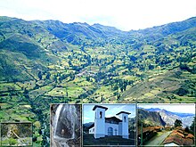
Llama District (Mariscal Luzuriaga)
| Llama district | |
|---|---|
 The Llama District is located in the southeast of the Mariscal Luzuriaga Province (marked in red) |
|
| Basic data | |
| Country | Peru |
| region | Ancash |
| province | Mariscal Luzuriaga |
| Seat | Llama |
| surface | 49.1 km² |
| Residents | 1070 (2017) |
| density | 22 inhabitants per km² |
| founding | November 22, 1905 |
| ISO 3166-2 | PE-ANC |
| politics | |
| Alcalde District | Rogelio Marcial Meléndez Miranda (2019-2022) |
Coordinates: 8 ° 54 ′ 55 ″ S , 77 ° 18 ′ 6 ″ W
The Llama district is located in the Mariscal Luzuriaga Province in the Ancash region of western Peru . The district was founded on November 22, 1905. It has an area of 49.1 km². The 2017 census counted 1070 inhabitants. In 1993 the population was 1731, in 2007 it was 1392. The district administration is located in the 2821 m high village of Llama with 153 inhabitants (as of 2017). Llama is located 8 km southeast of the provincial capital Piscobamba .
Geographical location
The Llama District is located in the southeast of the Mariscal Luzuriaga Province. The Río Yanamayo flows east along the southern district boundary .
The Llama district is bordered by the Musga district to the west and northwest, the Eleazar Guzmán Barrón district to the east and the San Nicolás and Yauya districts to the south (both in the province of Carlos Fermín Fitzcarrald ).
Web links
- Peru: Region Ancash (provinces and districts) at www.citypopulation.de

