Llumpa district
| Llumpa district | |||
|---|---|---|---|
 The district of Llumpa is located in the extreme southwest of the province of Mariscal Luzuriaga (marked in red) |
|||
| Symbols | |||
|
|||
| Basic data | |||
| Country | Peru | ||
| region | Ancash | ||
| province | Mariscal Luzuriaga | ||
| Seat | Llumpa | ||
| surface | 139 km² | ||
| Residents | 6191 (2017) | ||
| density | 45 inhabitants per km² | ||
| founding | October 28, 1889 | ||
| ISO 3166-2 | PE-ANC | ||
| politics | |||
| Alcalde District | Antonio Máximo Honorato Neri (2019-2022) |
||
| Political party | Movimiento Regional El Maicito | ||
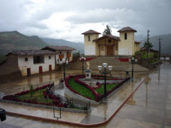
| Plaza de Armas in Llumpa | |||
Coordinates: 8 ° 58 ′ S , 77 ° 22 ′ W
The Llumpa district is located in the Mariscal Luzuriaga province in the Ancash region of western Peru . The district was founded on October 28, 1889. It has an area of 139 km². The 2017 census counted 6191 inhabitants. In 1993 the population was 5343, in 2007 it was 6066. The district administration is located in the village of Llumpa, which is about 3200 m high and has 372 inhabitants (as of 2017). Llumpa is 10 km south of the provincial capital Piscobamba .
Geographical location
The Llumpa district is located on the eastern flank of the Cordillera Blanca in the extreme southwest of the Mariscal Luzuriaga province. The main ridge of the Cordillera Blanca with the Nevado Pacaraju runs along the northwestern district boundary. The Quebrada Yuma and the Río Yanamayo flow east along the southern district boundary . In the northeast, the district extends to the confluence of the Río Pomabamba in the Río Yanamayo.
The district of Llumpa borders in the south and in the west on the district Yanama ( province Yungay ), in the north on the district Lucma and in the east on the district Yauya ( province Carlos Fermín Fitzcarrald ).
Web links
- Peru: Region Ancash (provinces and districts) at www.citypopulation.de


