
Things
| Things | |
|---|---|
 |
|
| State : |
|
| Canton : |
|
| District : | To run |
| BFS no. : | 2784 |
| Postal code : | 4243 |
| Coordinates : | 604.42 thousand / 254 420 |
| Height : | 404 m above sea level M. |
| Height range : | 341–865 m above sea level M. |
| Area : | 6.75 km² |
| Residents: | 729 (December 31, 2018) |
| Population density : | 108 inhabitants per km² |
| Website: | www.dittingen.ch |
 Church of St. Nicholas in Dittingen |
|
| Location of the municipality | |
  |
|
Dittingen is a municipality in the district of Laufen in the canton of Basel-Landschaft in Switzerland .
geography
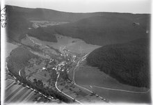
The municipality of Dittingen is located in a northern side valley of the Laufental on the southern slope of the Blue Chain. In the southeast the community borders on the Birs .
history
The place was first mentioned in a document in 1300. In 1435 the name "Tittingen" was written. From 1462 the community was owned by the Bishop of Basel. On the occasion of the Congress of Vienna in 1815, Dittingen was assigned to the Canton of Bern . In 1994 he moved to the canton of Baselland. The Church of St. Niklaus contains a number of stained glass windows by Hans Stocker .
coat of arms
The municipality's coat of arms shows Saint Wendelin in a black robe, with a golden stick and golden bag on a green field. Left and right in the background are two green deciduous trees. The background color is silver or white.
Attractions
photos
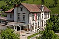
school

Dreisässenhaus


Others
The Dittinger Flugtage takes place every two years on the Dittingen airfield ( ICAO code LSPD).
Web links
- Official website of the community of Dittingen
- Daniel Hagmann : Dittingen. In: Historical Lexicon of Switzerland .
Individual evidence
- ↑ Permanent and non-permanent resident population by year, canton, district, municipality, population type and gender (permanent resident population). In: bfs. admin.ch . Federal Statistical Office (FSO), August 31, 2019, accessed on December 22, 2019 .
- ↑ coordinates LSPD