
Nenzlingen
| Nenzlingen | |
|---|---|
 |
|
| State : |
|
| Canton : |
|
| District : | To run |
| BFS no. : | 2789 |
| Postal code : | 4224 |
| Coordinates : | 609 298 / 255210 |
| Height : | 438 m above sea level M. |
| Height range : | 325–689 m above sea level M. |
| Area : | 3.66 km² |
| Residents: | 443 (December 31, 2018) |
| Population density : | 121 inhabitants per km² |
| Website: | www.nenzlingen.ch |
| Location of the municipality | |
  |
|
Nenzlingen ( Swiss German Aenzlige ) is a municipality in the district of Laufen in the canton of Basel-Landschaft in Switzerland .
geography

Nenzlingen lies in the Laufental at 447 m above sea level. M. on the blue south slope above the river Birs . Neighboring communities are Blauen BL , Brislach , Zwingen , Grellingen and Pfeffingen BL .
history
The area of Nenzlingen was inhabited early on, as a grave was found in the Birsmatten base grotto in 1944, which probably dates from the Mesolithic (approx. 7500-7000 BC). The oldest woman's skeleton was found in Switzerland.
The crossing over the Blattenpass between the Birstal and the Laufental above the community was already used by the Celts and Romans .
The settlement was first mentioned in a document in December 1298, when the dean of the cathedral Heinrich von Bechburg gave his son Konrad land on the Bruderholz, which touched on the property of Johannis dicti de Nenzlingen . The castle on the Kuenisberg near the Plattenpass fell apart early on , probably during the Basel earthquake in 1356.
In 1408 Messrs. Hans Ludemann von Rothberg and Messrs. Ramstein became fiefs. In 1462 the Bishop of Basel acquired the villages south of the Blauen from Emperor Friedrich III. as an imperial fief and proposed them to the Vogtei Zwingen.
In 1792 the French marched into the Laufental and Nenzlingen first belonged to the Raurachian Republic and from 1793 to the Mont-Terrible department . In 1815 the village was defeated by the decision of the Congress of Vienna federally and to the canton of Bern . On January 1, 1994, in connection with the re-establishment of the canton of Jura , the municipality decided to move to the canton of Basel-Landschaft .
coat of arms
Split shield: on the left, red with a silver key , origin unclear - on the right, silver with a blue bar with a half blue lily attached , the coat of arms of the Pfeffingen rulership to which the community once belonged. The coat of arms has been known since around 1900 and has existed in this way since 1946. Flag : white-red-blue.
economy
Agriculture, commuters to Laufen and towards Basel.
traffic
The community is located a little off the main road from Basel - Aesch to Laufen - Delsberg and is connected to it by a road. In addition, the village is connected by a post bus line from Zwingen Bahnhof and via Dittingen to Laufen. The next train stations on the Jura Railway are in Zwingen and Grellingen (each about 6 kilometers).
Attractions
- Baroque village church of St. Oswald
- Old school house
- Eggflue lookout point
- Glögglifels (about 1.2 km east of the village)
Web links
- Website of the municipality of Nenzlingen on baselland.ch
- Felix Müller and Patricia Zihlmann-Märki: Nenzlingen. In: Historical Lexicon of Switzerland .
Individual evidence
- ↑ Permanent and non-permanent resident population by year, canton, district, municipality, population type and gender (permanent resident population). In: bfs. admin.ch . Federal Statistical Office (FSO), August 31, 2019, accessed on December 22, 2019 .
- ^ Pierre Crotti: Mesolithic. In: Historical Lexicon of Switzerland . February 15, 2017 , accessed June 14, 2019 .
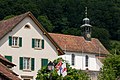
Nenzlinger Church from the southwest

Glögglifels

Nenzlinger Church from the southeast


