
Dorfer Bach (Niers)
| Dorfer Bach | ||
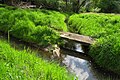
 Source area of the Dorfer Bach, pond of the Kaisermühle |
||
| Data | ||
| location | District of Viersen , North Rhine-Westphalia , Germany | |
| River system | Rhine | |
| Drain over | Dorfer Bach → Niers → Maas → Hollands Diep → North Sea | |
| River basin district | Meuse | |
| source | Mill pond of the Kaisermühle in Viersen 51 ° 15 '35 " N , 6 ° 22' 43" E |
|
| Source height | approx. 51 m above sea level NN | |
| muzzle | in the Alsbach coordinates: 51 ° 15 ′ 47 " N , 6 ° 24 ′ 42" E 51 ° 15 ′ 47 " N , 6 ° 24 ′ 42" E |
|
| Mouth height | approx. 38 m above sea level NN | |
| Height difference | approx. 13 m | |
The Dorfer Bach is a left tributary of the Niers in the Lower Rhine district of Viersen .
Bach description
The body of water that gave the glory of Viersen its name was the Dorfer Bach. It was called verse; the first settlement of Viersen that arose on both of its banks was named after him Verse. He was called Dorfer Bach until modern times, because he was responsible for the village, the oldest honor in Viersen. Today it is largely canalised in the urban area. Along with the Rintger Bach and the Hammer Bach, it was one of the most water-rich brooks in Viersen. It originated in over 100 sources in Noppdorf. Most of the springs came to light in the swamp area of the Kaisermühle and formed the mill pond there. The water of various spring waters and the outflowing water from the Kaisermühle combined to form the Dorfer Bach. He walked openly down Kaiserstrasse and Dülkener Strasse. In front of today's district court , the brook formed the village pond. Next to this was the Dorfer Bleiche , on which the linen produced in the village was bleached, which often had to be doused with the water of the Dorfer Bach. The brook crossed under the main street under one of its four wooden bridges and then continued on in an easterly direction via Goetersstrasse and Gerberstrasse. In the Kalversbenden he took up the Rintger Bach and then turned north. It split in the Rahser Bruch. One arm ran north into the Schwarzgraben of the Landwehr, which it fed, the second arm flowed east, picked up the Pielbach coming from the Pielbruch on the right and flowed into the Niers behind the Clörath mill.
The Dorfer Bach is now partially canalised in the urban area of Viersen. From Gerberstraße and Am Dorfer Bach it flows as an open ditch in an easterly direction, takes on the Rintger Bach and then flows east into the Alsbach (Viersen) . The care and maintenance of the water is the responsibility of the water and soil association of the Middle Niers, which is based in Grefrath .
Mills on the Dorfer Bach
A number of former water mills stand or stood by the Dorfer Bach :
- Kaisermühle , An der Kaisermühle 20
- Kimmelmühle , Kaiserstraße 10
- Goetersmühle , at the corner of Goetersstrasse and Brückenstrasse
- Biestenmühle , Goetersstraße (special needs school)
- Schricksmühle , corner of Sittarderstrasse and Gerberstrasse
gallery
It flows into the Alsbach

Stream course from Dorfer Bach

Stream tour on the Hormesfeld

Water flow of the Dorfer Bach at the Kaisermühle


literature
- Niederrheinischer Wassermühlen-Führer, by Hans Vogt, pp. 511-523
- From the water system in Alten Viersen, by Ferdinand Dohr, Heimatbuch Kreis Viersen 1974 pp. 47–55