Doustre
| Doustre | ||
|
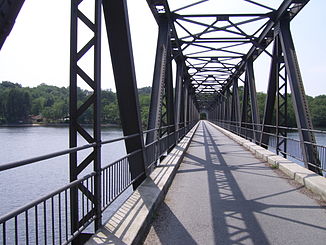
Bridge over the reservoir at Marcillac-la-Croisille |
||
| Data | ||
| Water code | FR : P13-0400 | |
| location | France , Nouvelle-Aquitaine region | |
| River system | Dordogne | |
| Drain over | Dordogne → Atlantic Ocean | |
| source | in the municipality of Rosiers-d'Égletons 45 ° 25 ′ 28 ″ N , 2 ° 0 ′ 21 ″ E |
|
| Source height | 695 m | |
| muzzle | at Saint-Martial-Entraygues in the Dordogne coordinates: 45 ° 6 ′ 38 " N , 1 ° 57 ′ 22" E 45 ° 6 ′ 38 " N , 1 ° 57 ′ 22" E |
|
| Mouth height | 191 m | |
| Height difference | 504 m | |
| Bottom slope | 9.9 ‰ | |
| length | 51 km | |
| Reservoirs flowed through | Barrage de la Valette | |
The Doustre is a river in France that runs in the Corrèze department in the Nouvelle-Aquitaine region . It rises on the border of the Regional Nature Park Millevaches en Limousin , in the municipality of Rosiers-d'Égletons , generally drains south and flows after 51 kilometers at Saint-Martial-Entraygues , near Argentat , in the storage area of the Barrage d'Argentat as a right tributary to the Dordogne . On the way it feeds the La Valette dam .
Places on the river
- Égletons
- Rosiers-d'Égletons
- Montaignac-Saint-Hippolyte
- Champagnac-la-Noaille
- Marcillac-la-Croisille
- La Roche-Canillac
- Saint-Bazile-de-la-Roche
