Eckenbach (Bigge)
| Eckenbach | ||
|
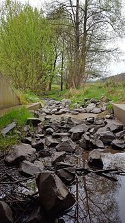
Dried out Eckenbach in the lower Eckenbach valley above Attendorn |
||
| Data | ||
| Water code | DE : 2766488 | |
| location |
Süderbergland
|
|
| River system | Rhine | |
| Drain over | Ihne → Bigge → Lenne → Ruhr → Rhine → North Sea | |
| source | southwest of Windhausen 51 ° 8 ′ 22 ″ N , 7 ° 51 ′ 13 ″ E |
|
| Source height | approx. 406 m above sea level NHN | |
| muzzle | at Attendorn in the Ihne coordinates: 51 ° 7 ′ 1 ″ N , 7 ° 53 ′ 35 ″ E 51 ° 7 ′ 1 ″ N , 7 ° 53 ′ 35 ″ E |
|
| Mouth height | approx. 256 m above sea level NHN | |
| Height difference | approx. 150 m | |
| Bottom slope | approx. 34 ‰ | |
| length | 4.4 km | |
| Catchment area | 5.599 km² | |
| Discharge A Eo : 5.599 km² at the mouth |
MNQ MQ Mq |
16.46 l / s 136.78 l / s 24.4 l / (s km²) |
The Eckenbach is an almost 4.4 kilometers long left and northwest tributary of the Ihne in the North Rhine-Westphalian district of Olpe .
geography
course
The Eckenbach rises in a forest southwest of Windhausen at an altitude of about 406 m above sea level. NHN .
From there it flows mainly in a south-easterly direction, takes in a few smaller streams along the way, including the Lichteneicken , and flows out at Attendorn just above the mouth of the river at approx. 256 m above sea level. NHN from the left into the Ihne.
The 4.4 km long course of the Eckenbach ends about 150 meters below its source, so it has a mean bed gradient of about 34 ‰.
Catchment area
The 5.599 km² catchment area of the Eckenbach lies in the natural areas of the South Sauerland Uplands and Sauerland Sinks . It is through him over the Ihne , the Bigge that Lenne the Ruhr and the Rhine to the North Sea dehydrated.
It borders
- in the east to the catchment area of the Fürstmicke , which flows into the Bigge
- in the west to that of the Wesebach , which is also a tributary of the Bigge
- and in the north to that of the Bernde brook , which drains into the Lenne via the Nuttmecke , the Oester and the Else .
Most of the catchment area is forested in the area of the upper reaches. on the middle reaches arable land dominates and the estuary is populated.
In the north of the catchment area lies the 20.6 hectare Eckenbach-Quellbach nature reserve .
Tributaries
Inflows with length in km, EZG in km² and MQ in l / s . Data according to ELWAS:
- Lichteneicken ( right ), 1.2 km, 0.69 km², 16.38 l / s
Localities
Attendorn is the only village on the Eckenbach .
Nature reserve
Individual evidence
- ↑ Martin Bürgener: Geographical Land Survey: The natural spatial units on sheet 110 Arnsberg. Federal Institute for Regional Studies, Bad Godesberg 1969. → Online map (PDF; 6.1 MB)
- ↑ a b Topographic map 1: 25,000
- ↑ a b Water directory of the State Office for Nature, Environment and Consumer Protection NRW 2010 (XLS; 4.67 MB) ( Notes )
- ↑ a b ELWAS specialist information system, Ministry for Climate Protection, Environment, Agriculture, Nature and Consumer Protection North Rhine-Westphalia ( notes )
