
Egyed
| Egyed | |||||
|
|||||
| Basic data | |||||
|---|---|---|---|---|---|
| State : | Hungary | ||||
| Region : | Western Transdanubia | ||||
| County : | Győr-Moson-Sopron | ||||
| Small area until December 31, 2012 : | Csorna | ||||
| District since 1.1.2013 : | Csorna | ||||
| Coordinates : | 47 ° 31 ' N , 17 ° 20' E | ||||
| Area : | 13.43 km² | ||||
| Residents : | 522 (Jan. 1, 2011) | ||||
| Population density : | 39 inhabitants per km² | ||||
| Telephone code : | (+36) 96 | ||||
| Postal code : | 9314 | ||||
| KSH kódja: | 20288 | ||||
| Structure and administration (as of 2020) | |||||
| Community type : | local community | ||||
| Mayoress : | Katalin Vadosné Varga (independent) | ||||
| Postal address : | Árpási u. 13 9314 Egyed |
||||
| (Source: A Magyar Köztársaság helységnévkönyve 2011. január 1st at Központi statisztikai hivatal ) | |||||


Egyed is a Hungarian community in the county Csorna in Győr-Moson-Sopron County . It has a good 500 inhabitants (as of 2013).
Geographical location
Egyed is located in the small Hungarian plain , a steppe area , a good 12 kilometers southeast of the district town of Csorna , on the Buga-csatorna canal. Neighboring municipalities are Rábacsanak , Rábapordány , Árpás and Sobor .
Attractions
- Crucifix ( Krisztus-kereszt ), created 1803
- Szentháromság Roman Catholic Church , built in 1773
- Schloss Stern
- Szentháromság Column ( Szentháromság-oszlop ), created in the 19th century
- World War Monuments ( I. és II. Világháborús emlékmű )

Buga-csatorna

Schloss Stern (used as a school until 2000)
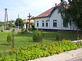
Local government

Roman Catholic Szentháromság Church

World War II Memorial by Károly Székely (1924)

Japanese pagoda tree in the courtyard


traffic
Roads No. 8419 and No. 8424 meet in Egyed. The community is connected to the railway line from Csorna to Pápa via the Egyed-Rábacsanak train station to the east of the village .
Individual evidence
- ↑ Helyi önkormányzati választások 2019 - Egyed (Győr-Moson-Sopron megye). Nemzeti Választási Iroda, accessed July 2, 2020 (Hungarian).
Web links
Commons : Egyed - collection of images, videos and audio files
- Egyed in Magyarország helységnévtára ( Hungarian )
- Egyed in A Pallas nagy lexikona (Hungarian)
- Egyed alkotásai bei köztérkép (Hungarian)