
Sopronnémeti
| Sopronnémeti | |||||
|
|||||
| Basic data | |||||
|---|---|---|---|---|---|
| State : | Hungary | ||||
| Region : | Western Transdanubia | ||||
| County : | Győr-Moson-Sopron | ||||
| Small area until December 31, 2012 : | Csorna | ||||
| District since 1.1.2013 : | Csorna | ||||
| Coordinates : | 47 ° 32 ' N , 17 ° 12' E | ||||
| Area : | 7.09 km² | ||||
| Residents : | 258 (Jan. 1, 2011) | ||||
| Population density : | 36 inhabitants per km² | ||||
| Telephone code : | (+36) 96 | ||||
| Postal code : | 9325 | ||||
| KSH kódja: | 02617 | ||||
| Structure and administration (as of 2020) | |||||
| Community type : | local community | ||||
| Mayor : | Sándor Bognár (Fidesz-KDNP) | ||||
| Postal address : | Petőfi Sándor u. 22 9325 Sopronnémeti |
||||
| Website : | |||||
| (Source: A Magyar Köztársaság helységnévkönyve 2011. január 1st at Központi statisztikai hivatal ) | |||||


Sopronnémeti is a Hungarian community in the county Csorna in Győr-Moson-Sopron County . It is located on the small river Keszeg-ér south of Csorna .
Community partnerships
Attractions
- Evangelical church, built 1992–1997 according to plans by Tamás Nagy
- Roman Catholic Church Szent András Apostol , built in 1717 (Baroque)
- Sághy Castle ( Sághy-kastély ), built in the 19th century
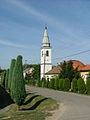
Evangelical Church in Sopronnémeti
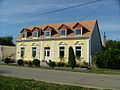
Municipal administration in Sopronnémeti

Community park


traffic
Roads No. 8602 and No. 8604 intersect in Sopronnémeti, and the M86 motorway runs south of the village . The Szil- Sopronnémeti station on the southern edge of the municipality is connected to the railway line from Csorna to Szombathely .
Web links
Commons : Sopronnémeti - collection of images, videos and audio files