Malá Mača
| Malá Mača | ||
|---|---|---|
| coat of arms | map | |

|
|
|
| Basic data | ||
| State : | Slovakia | |
| Kraj : | Trnavský kraj | |
| Okres : | Galanta | |
| Region : | Dolné Považie | |
| Area : | 7.975 km² | |
| Residents : | 590 (Dec. 31, 2019) | |
| Population density : | 74 inhabitants per km² | |
| Height : | 121 m nm | |
| Postal code : | 925 21 ( Sládkovičovo post office ) | |
| Telephone code : | 0 31 | |
| Geographic location : | 48 ° 13 ' N , 17 ° 38' E | |
| License plate : | GA | |
| Kód obce : | 582638 | |
| structure | ||
| Community type : | local community | |
| Administration (as of November 2018) | ||
| Mayor : | František Hontvári | |
| Address: | Obecný úrad Malá Mača Hlavná ulica 127/46 925 21 Sládkovičovo |
|
| Website: | www.obecmalamaca.sk | |
| Statistics information on statistics.sk | ||
Malá Mača (until 1948 Slovak "Malý Mačad"; Hungarian Kismácséd ) is a municipality in the west of Slovakia with 590 inhabitants (December 31, 2019), which for Okres Galanta , part of kraj Trnavský belongs.
geography
The community is located in the Slovakian Danube lowlands at the confluence of the Dolný Dudváh and Gidra rivers . The municipality is flat, largely deforested and covered by fertile black soils. The center of the village is located at an altitude of 121 m nm and is two and a half kilometers from Sládkovičovo and ten kilometers from Galanta .
Neighboring communities are Abrahám in the north, Veľká Mača in the east and Sládkovičovo in the south and west.
history
Malá Mača together with the neighboring village Veľká Mača was first mentioned in writing in 1326 as Mached . But before that there was a church that was built in the 13th century. After 1326 the distinction is clear, for example in 1335 ( Mached utraque ) or 1412 ( Kysmached ). The village belonged to the lower nobility: in 1553 it was the Erdőmegyi , Zomor , Szalay and Kapróczy families , in the 18th century Esterházy and the Schintau estate . In 1553, eleven portals were recorded in a tax register.
In 1663 the village was devastated by the Turks, but from 1703–11 by the imperial army and the Kuruzzen. In 1828 there were 74 houses and 334 inhabitants who were employed in agriculture.
Until 1918, the place in Pressburg County belonged to the Kingdom of Hungary and then came to Czechoslovakia or now Slovakia. Due to the First Vienna Arbitration Award , he was once again in Hungary from 1938-45.
In 1986 Malá Mača was incorporated into the town of Sládkovičovo, but became independent again in December 2002.
population
According to the 2011 census, Malá Mača had 584 inhabitants, including 287 Magyars, 279 Slovaks and eight Czechs. 13 residents did not answer. 409 residents belonged to the Roman Catholic Church, 76 residents to the Evangelical Church AB, four residents to the Seventh-day Adventists, three residents each to the Evangelical Methodist Church and three to the Orthodox Church, two residents to the Reformed Church and one resident to the Apostolic Church . 62 inhabitants had no denomination and the denomination of 24 inhabitants has not been determined.
Attractions
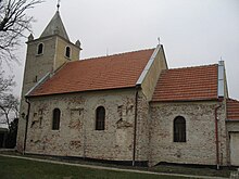
- Roman Catholic Margaret Church in Romanesque style from the 13th century, about one kilometer from the village. According to local oral tradition, the former village stood around the church before the residents left it in the 17th century due to Turkish attacks and built a new village at the current location. In memory of the tower cross there is a metal crescent .
Individual evidence
- ↑ 2011 census by ethnicity (Slovak) ( Memento of the original from February 3, 2013 in the Internet Archive ) Info: The archive link was inserted automatically and has not yet been checked. Please check the original and archive link according to the instructions and then remove this notice.
- ↑ 2011 census by denomination (Slovak)
Web links
- Entry on e-obce.sk (Slovak)

