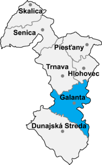
Okres Galanta
| Overview maps | |
|---|---|

|

|
| Basic data Okres Galanta | |
| Kraj : | Trnavský kraj |
| Area : | 641.74 km² |
| Residents : | 94,147 (December 31, 2019) |
| Population density : | 146.65 inhabitants / km² |
| License plate : | GA |
| District code: | 202 |
| Administrative division | |
| Cities: | 3 |
| Municipalities (excluding cities): | 33 |
| further information | |
| Website: | www.galantaou.sk |
| Statistics information about the Okres on statistics.sk | |
Galanta (German Gallandau ) is an Okres (administrative area) in western Slovakia with 94,936 inhabitants (2004, 2001 there were 94,533, of which 56,213 (59.5%) Slovak and 36,518 (38.6%) Hungarian) and an area of 641 km² .
The district lies in the Danube Plain (Podunajská rovina) bounded in the east by the Waag and in the south by the Little Danube . In the north, the districts of Trnava and Hlohovec connect , in the east on a short stretch of the Okres Nitra and Šaľa in Nitriansky kraj , in the south of the Okres Dunajská Streda and in the east of the Okres Senec in Bratislavský kraj .
Historically, it was mostly in the former Pressburg county (west), a smaller part in the east belongs to the former Neutra county (see also the list of historical counties of Hungary ).
Cities
- Galanta
- Sereď
- Sládkovičovo ( Diosek )
Communities
|
|
|
The district office is in Galanta , branches are in Sereď and Sládkovičovo .
Culture
In the article Protected objects in the Okres Galanta you can find about the objects protected by the Slovak Monuments Office in the Okres.