Okres Trnava
| Overview maps | |
|---|---|

|

|
| Basic data Okres Trnava | |
| Kraj : | Trnavský kraj |
| Area : | 741.33 km² |
| Residents : | 132,779 (December 31, 2019) |
| Population density : | 179.19 inhabitants / km² |
| License plate : | TT |
| District code: | 207 |
| Administrative division | |
| Cities: | 1 |
| Municipalities (excluding cities): | 44 |
| Statistics information about the Okres on statistics.sk | |
The Okres Trnava (German District Trnava ) is an administrative region in the west of Slovakia with 132,779 inhabitants (as of December 31, 2019) square kilometers and an area of the 741st
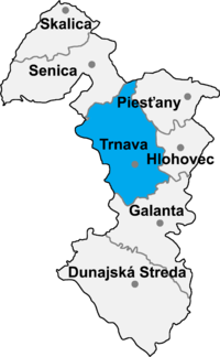
The district extends between the Trnava hills ( Trnavská pahorkatina ) and the other Danubian Hills ( Dunajská pahorkatina ) around the eponymous town of Trnava . The north-western border is shaped by the main ridge of the Little Carpathians . The Trnávka , Parná and Gidra flow through the Okres from the northwest, in the east the Dudváh runs through on the way south, at Šúrovce the Okres has a small part of the Waag . In the north it borders on the Senica district , in the east on the Piešťany and Hlohovec districts , in the south on the Galanta district and in the west on the Malacky , Pezinok and Senec districts in Bratislavský kraj .
Historically, the area is mostly in the former Pressburg county (west), a small part around the town of Bučany belongs to the former Neutra county (see also the list of historical counties in Hungary ).
Cities
- Trnava ( Tyrnau )
Communities
|
|
The district office is in Trnava .
Culture
In the article Protected objects in the Okres Trnava you can find about the objects in the Okres protected by the Slovak Monuments Office.