Dolná Krupá
| Dolná Krupá | ||
|---|---|---|
| coat of arms | map | |

|
|
|
| Basic data | ||
| State : | Slovakia | |
| Kraj : | Trnavský kraj | |
| Okres : | Trnava | |
| Region : | Dolné Považie | |
| Area : | 24.632 km² | |
| Residents : | 2,383 (Dec 31, 2019) | |
| Population density : | 97 inhabitants per km² | |
| Height : | 192 m nm | |
| Postal code : | 919 65 | |
| Telephone code : | 0 33 | |
| Geographic location : | 48 ° 29 ' N , 17 ° 39' E | |
| License plate : | TT | |
| Kód obce : | 506923 | |
| structure | ||
| Community type : | local community | |
| Administration (as of November 2018) | ||
| Mayor : | Marek Dean | |
| Address: | Obecný úrad Dolná Krupá nám. L. van Beethovena 139/1 91965 Dolná Krupá |
|
| Website: | www.dolnakrupa.sk | |
| Statistics information on statistics.sk | ||
Dolná Krupá (German Unterkrupa , Hungarian Alsókorompa ) is a municipality in western Slovakia . It is located in the Danube Hills about twelve kilometers from Trnava .
The place was first mentioned in writing as Crumba in 1113 .
Attractions
- the Roman Catholic Church of St. Andrew in the classicist style from the years 1807-11, built on the foundations of an older Gothic church
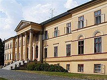
- the Dolná Krupá chateau in the classical style from the 18th century, originally built in the baroque style
See also: List of listed objects in Dolná Krupá
Web links
Commons : Dolná Krupá - collection of images, videos and audio files

