Majcichov
| Majcichov | ||
|---|---|---|
| coat of arms | map | |

|
|
|
| Basic data | ||
| State : | Slovakia | |
| Kraj : | Trnavský kraj | |
| Okres : | Trnava | |
| Region : | Dolné Považie | |
| Area : | 18.197 km² | |
| Residents : | 2,158 (Dec 31, 2019) | |
| Population density : | 119 inhabitants per km² | |
| Height : | 149 m nm | |
| Postal code : | 919 22 | |
| Telephone code : | 0 33 | |
| Geographic location : | 48 ° 17 ' N , 17 ° 38' E | |
| License plate : | TT | |
| Kód obce : | 507296 | |
| structure | ||
| Community type : | local community | |
| Administration (as of November 2018) | ||
| Mayor : | Tibor Marek | |
| Address: | Obecný úrad Majcichov č. 606 919 22 Majcichov |
|
| Website: | www.majcichov.sk | |
| Statistics information on statistics.sk | ||
Majcichov (until 1927 Slovak and "Matejchov"; Hungarian Majtény ) is a municipality in the west of Slovakia , with a population of 2,158 (as of December 31, 2019). It belongs to the Okres Trnava and the higher district Trnavský kraj .
geography
The municipality is located in the Slovakian Danube lowlands at the confluence of the Trnávka and Dolný Dudváh . The town center, at an altitude of 149 m nm , is 11 kilometers away from Trnava .
The Majcichov cadastral area borders on the following municipalities: Zeleneč , Opoj , Vlčkovce , Sereď , Hoste , Abrahám , Pavlice and Voderady .
history
Majcichov was first mentioned in writing in 1266 and belonged to various landowners. In 1828 the place had 84 houses and 603 inhabitants.
Attractions
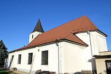
- Roman Catholic Church, originally built in the Romanesque style in the 13th century. The history of the church tower , however, goes back to the 9th century.
- Baroque chapel from the 18th century
- Neoclassical country castle from the end of the 19th century
- The memorial house of Ján Palárik , who died here in 1870
Web links
Commons : Majcichov - collection of images, videos and audio files

