Eisgrundgraben
| Eisgrundgraben | ||
|
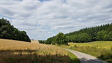
View up the valley into the Eisgrundgraben between the Geißberg and the Kühruh (left) and the Heiligenberg (right) in Dittwar (2017) |
||
| Data | ||
| Water code | DE : 24692224 | |
| location |
Tauberland
|
|
| River system | Rhine | |
| Drain over | Ölbach → Muckbach → Brehmbach → Tauber → Main → Rhine → North Sea | |
| Upper course | southwest of Dittwar 49 ° 33 ′ 53 " N , 9 ° 36 ′ 37" E |
|
| Source height | approx. 335 m above sea level NN | |
| muzzle | at Dittwar in the Ölbach coordinates: 49 ° 35 '27 " N , 9 ° 37' 54" E 49 ° 35 '27 " N , 9 ° 37' 54" E |
|
| Mouth height | approx. 235 m above sea level NN | |
| Height difference | approx. 100 m | |
| Bottom slope | approx. 29 ‰ | |
| length | 3.5 km | |
The Eisgrundgraben is a creek about 3.5 km long in the Main-Tauber district in the north of Baden-Württemberg , which flows into the Ölbach near Dittwar .
geography
The Eisgrundgraben arises at a height of about 335 m above sea level. NN from a source with only intermittent water in the Buchbaum corridor directly north of a forest path a good three kilometers south-southwest of the Tauberbischofsheimer district of Dittwar.
It initially flows about a kilometer north in the name- giving corridor Eisgrund through an approximately 100 m wide agricultural strip, which is lined with mixed forest on the left and right. After a good three hundred meters, a small forest stream flows towards him on his left. The trench then flows through the hallway Eisgrundboden and then through the hallway Hägelesboden at the southeast foot of the 365.9 m high tensile mountain pass. In the Inneres Pfarrfeld corridor , it is strengthened by another brook from the left. The Eisgrundgraben then runs north-northeast at the foot of the Heiligenberg ( 347 m ) west along the wooded Hesselrain .
It now runs through the Kurzes Gewann corridor towards the village of Dittwar, where it finally joins the Ölbach from the right at an altitude of about 235 m .
Geology and natural spaces
The catchment area is in the Tauberland natural area . It is characterized by the Upper Muschelkalk on the upper reaches of the trench and by the Middle Muschelkalk of the Triassic in the mouth area .
Flood
On Corpus Christi Day , June 21, 1984, heavy rain led to a flood disaster in the valleys of the Ölbach and its tributaries as well as in some neighboring waters. Dittwar and the surrounding communities were affected. There was damage of around 90 million German marks .
See also
Individual evidence
- ↑ a b c State Institute for the Environment Baden-Württemberg (LUBW) ( information )
- ^ Horst Mernsching, Günter Wagner: Geographical land survey: The natural space units on sheet 152 Würzburg. Federal Institute for Regional Studies, Bad Godesberg 1963. → Online map (PDF; 5.3 MB)
- ↑ Geology roughly based on: Map server of the State Office for Geology, Raw Materials and Mining (LGRB) ( notes )
- ↑ Harald Fingerhut: Wave rolls with force through Weinort. The Corpus Christi flood on June 21, 1984 caused enormous damage, especially in Königheim, but also in Kupprichhausen and Dittwar. . In: Franconian news . July 22, 2016. Online at www.fnweb.de. Retrieved November 20, 2016.
literature
- Topographical map 1: 25,000 Baden-Württemberg North, as single sheet No. 6323 Tauberbischofsheim West and No. 6324 Tauberbischofsheim East
Web links
- Course of the Eisgrundgraben on the map service of the State Institute for the Environment, Measurements and Nature Conservation Baden-Württemberg (LUBW)

