El Nido-Taytay Managed Resource Protected Area
| El Nido-Taytay Managed Resource Protected Area | ||
|---|---|---|
| El Nido Bay | ||
|
|
||
| Location: | Philippines | |
| Specialty: | Palawan | |
| Next city: | El Nido | |
| Surface: | 923.34 km² | |
| Founding: | October 8, 1998 | |
The El Nido-Taytay Managed Resource Protected Area is located 238 kilometers northeast of Puerto Princesa , the capital of the Palawan Province in the Philippines . It was established on October 8, 1998 when Presidential Decree 32 came into force.
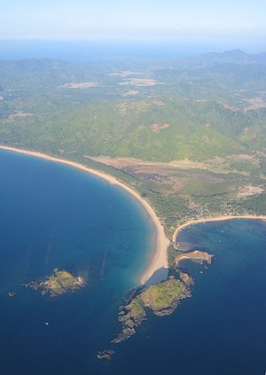
The El Nido-Taytay Managed Resource Protected Area is a combined landscape and marine protected area and covers an area of 923.34 km², of which 527.43 km² are marine ecosystems . The core zone of the nature park includes the Bacuit Archipelago , which is known worldwide for its bizarre island landscape. The coastline is a mixture of towering rocky cliffs, sandy beaches, mangrove forests and extensive tidal flats . Numerous small streams and rivers flow into the sea on the coast of the island of Palawan. There are numerous coral reefs off the coast . The islands in the Bacuit archipelago and the coast of El Nido are made of karst limestone . The highest point is on the island of Cadlao and reaches 640 meters above sea level. The Malampaya Sound Protected Landscape / Seascape connects to the south of the nature reserve .
The nature reserve serves not only to protect marine flora and fauna , but also to protect and develop the livelihoods of the local population living by the sea. A total of 21 barangays , 18 of the municipality of the municipality of El Nido and three of the municipality of Taytay , are located in the area of the nature park. The establishment of the nature park also serves to develop tourism in the region.


