Emilia (region)

The Emilia (formerly German also Emilien ) is a region in northern Italy , which together with the Romagna modern political region Emilia-Romagna forms.
Naming
The name Emilia is derived from the Via Aemilia , a Roman road that connected the cities of Placentia ( Piacenza ) and Ariminum ( Rimini ). This in turn was named after the Roman patrician family of the Aemilians and was commissioned by the Roman consul Marcus Aemilius Lepidus in 187 BC. Was created. At first Emilia was part of Gallia Cisalpina , or was called Provincia Ariminum . Aemilia was initially just a popular name, for example in Martial's poems . The designation did not appear as an official name until the 2nd century.
expansion
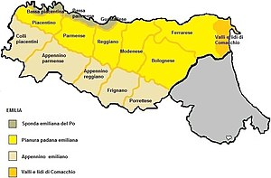
Emilia is bounded to the east by the Sillaro and Reno rivers, which separate the region from Romagna, and to the north by the Po . In the south, the watershed of the Apennines forms the boundary to Liguria and Tuscany .
The region thus includes the present-day Italian provinces of Piacenza , Parma , Reggio Emilia , Modena and Ferrara as well as the metropolitan city of Bologna (excluding the municipalities of Imola , Dozza and the valley of Santerno ).
history
→ see also: Emilia-Romagna # history
The main political powers in the area up to the Risorgimento were the Duchies of Modena and Reggio , Parma and Piacenza and Ferrara . For a long time Bologna was a border town between Emilia and Romagna. Apart from short interludes, however, was almost always the Papal States the dominant power.
literature
- Maria Maffi: Componenti culturali nei siti neolitici emiliani tra Neolitico Recente e Finale , tesi, Lyon, Trient 2013 ( online , PDF)
Coordinates: 44 ° 30 ′ 0 ″ N , 11 ° 18 ′ 0 ″ E
