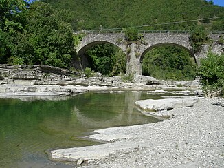
Santerno
| Santerno | ||
|
Location of the Santerno |
||
| Data | ||
| location | Romagna , Italy | |
| River system | Reno | |
| Drain over | Reno → Adria | |
| River basin district | Northern Apennines | |
| source | near the Futapass in Firenzuola | |
| Source height | 1222 m slm | |
| muzzle | near Voltana (Gem. Lugo ) in the Reno coordinates: 44 ° 34 ′ 3 ″ N , 11 ° 57 ′ 50 ″ E 44 ° 34 ′ 3 ″ N , 11 ° 57 ′ 50 ″ E
|
|
| length | 103 km | |
| Catchment area | 700 km² | |
| Medium-sized cities | Imola | |
| Small towns | Firenzuola , Castel del Rio , Fontanelice , Borgo Tossignano , Casalfiumanese , Mordano , Bagnara di Romagna , Sant'Agata sul Santerno | |
The Santerno is a Romagna river with a length of 103 km, but its first 27 km is in the municipality of Firenzuola ( metropolitan city of Florence ), i.e. in the Tuscan Romagna.
geography
The Santerno rises near the Futa Pass at 1222 meters above sea level in the Apennines in a natural amphitheater with Firenzuola in the center . It is the largest tributary of the Reno , both in terms of its length and its water flow . Its catchment area exceeds 700 km², up to the bridge of Via Emilia in Imola alone , it covers 423 km², of which 231 is in Tuscany and 192 in Romagna . At Castel del Rio the river runs through the 1499 by Obizzo Alidosi commissioned bridge Ponte Alidosi , by Andrea Gurrieri was realized. It was restored several times and declared a National Monument (Monumento nazionale) in 1897 .
history
The Romans knew him as Vatrenus (little Reno), but on the Peutinger map he is already called Santernus . Since then, it has changed its course, both naturally and as a result of artificial interventions. The existence of a hamlet called Santerno in Ravenna , which is now near the Lamone River , confirms that it flowed east of Bagnacavallo in ancient times . After Imola the river split into two arms, the north-east towards Ravenna probably disappeared in the eighth century, while the north continues to flow to the Po . The Santerno was a constant threat to the population. The dikes in the area of Massa Lombarda, for example, broke 14 times between 1679 and 1778 .
photos
Web links
Individual evidence
- ↑ Official website of the Sistema Informativo Ambientale della Regione Toscana (SIRA), accessed on July 31, 2012 (Ital.)
- ↑ Official website of the municipality of Castel del Rio on the Ponte Alidosi, accessed on August 16, 2012 (Ital.) ( Memento of the original from June 21, 2013 in the Internet Archive ) Info: The archive link was automatically inserted and not yet checked. Please check the original and archive link according to the instructions and then remove this notice.


