
Ename
| Ename | |||
|---|---|---|---|
|
|||
| State : |
|
||
| Region : | Flanders | ||
| Province : | East Flanders | ||
| District : | Oudenaarde | ||
| Coordinates : | 50 ° 51 ' N , 3 ° 38' E | ||
| Height: | 14 m | ||
| Post Code: | 9700 | ||


Ename is a village on the Scheldt in the Belgian province of East Flanders , which is now part of the city of Oudenaarde .
history
In the 1970s, the foundations of a fortification were discovered in Ename on the right bank of the Scheldt, which had been laid out by Emperor Otto II as a border fortification between Valenciennes and the margraviate of Antwerp against France . Already in 1034 (not 1033) Ename was destroyed after the conquest by Baldwin IV , Count of Flanders , which led to its own development in the neighboring village of Oudenaarde.
After a long rebellion, Count Baldwin V reconciled himself with the German Empire in 1056. Between 1062 and 1063 the count acquired the margraviate of the regent, Anno II , Archbishop of Cologne, and bought the allod of Ename des Hermann II (Lorraine) (Count Palatine of Lorraine, but still under the tutelage of Archbishop Anno II).
The Lorraine bulwark finally disappeared in 1062 after the establishment of the Saint Salvator Abbey. The abbey was burned down during the iconoclasm of 1566 and confiscated in the French Revolution .
As lords of the castle ( Margraves of Ename ) appear:
- Gottfried the Prisoner , † after 995 Count of Verdun ,
- Hermann von Eenham , † 1029, his son
The archaeological site of Ename has been awarded the European Heritage Label by the Belgian state . The history of Ename, especially the High Middle Ages, is presented in the Provincial Archaeological Museum Ename , where important finds are also shown.
literature
- FJ Van Droogenbroeck: De markenruil Ename - Valenciennes en de investituur van de graaf van Vlaanderen in de mark Ename , Handelingen van de Geschied- en Oudheidkundige Kring van Oudenaarde 55 (2018) pp. 47-127 .
Web links

Ruins of the Saint Salvator Abbey

Laurentiuskirche
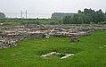
Ruins of the Saint Salvator Abbey


