
Ensmannsreut
|
Ensmannsreut
City of Waldkirchen
Coordinates: 48 ° 46 ′ 10 ″ N , 13 ° 36 ′ 55 ″ E
|
||
|---|---|---|
| Postal code : | 94065 | |
| Area code : | 08581 | |
Location of Ensmannsreut in Bavaria |
||
 Ensmannsreut
|
||

The village of Ensmannsreut is a district of the city of Waldkirchen in the Lower Bavarian district of Freyung-Grafenau .
location
The place is located in a wide hollow in the southern Bavarian Forest . To the northeast of the village rises the Haidel , which at 1167 m is the second highest elevation in the Lower Bavarian Forest after the Dreisesselberg . Passau is about 30 km away in a south-westerly direction.
history
The origin of the place falls into the high medieval settlement of the "northern forest". As in numerous places in the Bavarian Forest, the suffix "-reut" (clearing, arable to clear) indicates that the village of Ensmannsreut is a clearing foundation. The place was first mentioned in a document in 1236, when Bishop Rüdiger of Passau allowed the impoverished nuns in Niedernburg to receive income from fish during Lent, including two pounds pfennig (480 pfennigs) from the village of "Enczemannesrawte". In 1298 the residents of Ensmannsreut managed to buy themselves out of the "hay service" (= delivery of hay) that they had to do for the monastery bailiff. The place was on the Goldener Steig , a salt trade route connecting the Danube and Bohemia , so that the villagers could participate in the hem trade (hem = horse load).
According to the oldest Niedernburg land register from 1630, the place consisted of seven fiefs (property with basic equipment). The Ensmannsreuter farmers had to pay 1 shilling and 24 pfennigs valid (property tax) and 7 pfennigs royal tax to the monastery of Niedernburg on Epiphany (January 6 ), and the pastor had to be given the tithe of the crops. Since 1593 the place was under the care and regional court Leoprechting .
For centuries the village was spared from major armed conflicts. The repeatedly recurring plague epidemics brought great misfortune, especially during the Thirty Years' War and in the years that followed. Plague columns preserved in many places indicate this.
With the secularization in 1803, the last Prince-Bishop of Passau, Leopold Graf von Thun, lost his land. The area and thus Ensmannsreut became part of the Kingdom of Bavaria . Ensmannsreut belonged to the parish of Waldkirchen for centuries. On December 1, 1937, the branch and later parish Böhmzwiesel was formed, to whose district the village has belonged ever since. Politically, Ensmannsreut has been part of the Böhmzwiesel community since the community was formed in 1818. As part of the regional reform , when this community was dissolved on January 1, 1978, Ensmannsreut was incorporated into the town of Waldkirchen.
Chapels
South of the village is the baroque Lady Chapel , built in 1708, beautifully situated in the landscape . In the direction of Steingupf (hill on the eastern edge of the village) you can find the so-called “Unknown Cross Chapel”. Furthermore, a new chapel in honor of St. Martin was consecrated in the town center in 2001.

The figure of Mary
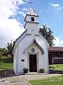
St. Martin Chapel

St Martin figure


structure
The place is rural. Apartments are offered.
Attractions
In the list of architectural monuments in Waldkirchen there are three architectural monuments for Ensmannsreut .
Web links
Individual evidence
- ^ Federal Statistical Office (ed.): Historical municipality directory for the Federal Republic of Germany. Name, border and key number changes in municipalities, counties and administrative districts from May 27, 1970 to December 31, 1982 . W. Kohlhammer GmbH, Stuttgart and Mainz 1983, ISBN 3-17-003263-1 , p. 628 .

Appmannsberg | Atzesberg | Auerbach | Bernhardsberg | Böhmzwiesel | Breinhof | Book Mill | Dickenbüchel | Thorn | Edelmühle | Edwaidl | Ensmannsreut | Erlauzwiesel | Freshness | Gaisberg | Vulture Mill | Großwies | Hauzenberg | Hochreut | Höhenberg | Holzfreyung | Höpplhof | Kanau | Karlsbach | Karlsbachmühle | Bold | Lammersreut | Manzing | Mayersäge | Mitterleinbach | Neidlingerberg | Oberfrauenwald | Oberhöhenstetten | Oberleinbach | Oberndorf | Ödhof | Pepper mill | Pilgramsberg | Pollmannsdorf | Raffelsberg | Edge saw | Ratzing | Reut | Reutmühle | Richardsreut | Rohrwies | Sassbach | Saßbachmühle | Sattlmühle | Saußmühle | Schauerbach | Wrong way | Schlößbach | Sickling | Solla | Stadl | Stilt mill | Stierberg | Stocking | Traxing | Unholdenberg | Unterhöhenstetten | Waldkirchen | Pasture | Werenain | Wotzmannsreut | Zimmermandling