Kefalari
|
Local community Kefalari Τοπική Κοινότητα Κεφαλαρίου (Κεφαλάρι) |
||
|---|---|---|
|
|
||
| Basic data | ||
| Country |
|
|
| region | Peloponnese | |
| Regional district | Argolis | |
| local community | Argos-Mycenae | |
| Parish | Mykines | |
| Geographic coordinates | 37 ° 36 ' N , 22 ° 42' E | |
| Height above d. M. |
83 m (average) |
|
| surface | 10.198 km 2 | |
| Residents | 800 (2011) | |
| very large karst spring Κεφαλάρι (dries up in dry seasons) | ||
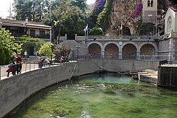
Kefalari ( Greek Κεφαλάρι ( n. Sg. ) , Source '(from which abundant water gushes) ) Kefalari is the name of 2 villages and 2 districts of cities in Greece. Here, the local community on the edge of the Argos plain in the Peloponnese is described. The village has formed around a large karst spring, which is geologically significant, was part of the mythology of gods among the ancient Greeks and is now an Orthodox pilgrimage site.
geography
Kefalari is a local community in the municipality of Argos town . The local community belongs to the municipality of Argos-Mycenae with the two villages Kefalari (677 inhabitants) and Magoula (123). Kefalari is located about six kilometers southwest of the city of Argos- Here, at the foot of the Chaon mountain to the plain, underground karst water is pushed to the surface in a large karst spring. The Erasino waters, the name of a river god in ancient times, flows into the Argolic Gulf after a five-kilometer run in Nea Kios . In the village, the spring is built into a lake surrounded by plane trees.
Above the source there is a karst cave that leads around 60 meters into the mountain. Today the cave is dedicated to Our Lady. Cave, spring and a church ("Zoodochos Pigi", "Panagia Kefalariotissa") shape the landscape and make the ensemble an orthodox pilgrimage site, especially for the nearby Nea Kios.
Geology and hydrogeology
Most of the karst water of this spring, as well as the other karst springs in front of and directly on the Argolic Gulf, comes underground from " Katavothren " (Greek "Ponore") from Poljen of the Arcadian highlands (large Tripoli basin, Argon Pedion ) and from Poljen of the highlands of Korinthia and Argolis ( Stymphalia , Alea / Skotini). As is common hydrogeologically, the karst water flowing underground at the foot of the mountains is pushed to the surface to form the fertile alluvial plain on the Argolic Gulf .
In a large scientific study (geology and hydrogeology), especially on the hydrogeological conditions and the closed basins in Arcadia, Corinthia and Argolis, it could be proven that the waterways lead to the east and south-east to the Argolic Gulf, as large fault structures favor hydrotectonic waterways. The distribution of the water to different sources was quantified and documented by numerous chemical and physical coloring tests (tracing tests from 1983 and 1984).
For the ancient Greeks, sources were always linked to their gods mythology. For Kefalari they suspected a connection to the Stymphalian Sea . According to the above-mentioned study by Morfis etal, dyeing tests have shown connections to the Polje Skafidia (Stymphalia complex in Corinthia) and Polje Alea / Skotini in the Argolis. In contrast to the submarine karst spring at Kiveri (cf. " Dine (Arcadia) "), the amount of water in the Kefalari spring fluctuates from a great deal to zero (in the dry season). The pilgrimage part of the cave above the current spring is referred to in the study as the former waterway of a geologically earlier karstification state.
Nearby archaeological find
About two kilometers west of the village are the remains of an ancient building from the Hellenistic period, the so-called pyramid of Kefalari . It is the stump of a pyramid made of polygonal masonry, which formed the base of a building, the upper part of which was made of clay or wood. The assumption that it was a tomb is now out of date; it is assumed that the building served as a watch and defense tower, as similar buildings on the edge of the Argolida suggest.
Chain of karst springs on the Argolic Gulf
literature
- William Smith : Dictionary of Greek and Roman Geography, London (Walton and Maberly) 1854 in English
- Richard Speicher: Southern Greece. Art and travel guide, Volume 2 Peloponnes, Stuttgart et al. (Kohlhammer) 1980, ISBN 3-17-005395-7 , p. 119
- Lambert Schneider : Peloponnese. Mycenaean palaces, ancient sanctuaries and Venetian forts in the south of Greece, Cologne (DuMont) 2001, ISBN 3-7701-4599-2 , p. 178
- Morfis, A. (Athens), Zojer, H. (Graz). Karst Hydrogeology of the Central and Eastern Peloponnesus (Greece). Styrian contributions to hydrogeology 37/38. 301 pages, Graz 1986. in English
Web links
- Description of Kefalaris on the web site of the regional administration of the Argolis region, in English [1]
- Argos and "Kephalári", W. Smith, Dictionary of Greek and Roman Geography… online (English) at tufts, edu [2]
Individual evidence
- ↑ See Dine (Arcadia)
- ↑ Morfis et al., Pp. 24-33 and pp. 276ff. See literature
- ↑ Morfis et al, graphic p. 281
- ↑ Morfis et al, p. 199


