
Argon Pedion
Argon Pedion (modern Greek: Αργόν Πεδίον , ancient Greek: Ἀργὸν Πεδίον ) means lazy field (barren field). The term goes back to the travel writer Pausanias (110-180 AD). Argon Pedion also stands for the name of the "drainless basin" in the Arcadian highlands in Greece. “Barren field”, because fields are often flooded into the vegetation phase, or even today a temporary lake can arise when there is a lot of winter rain. The intensive karstification (underground drainage in the pending, broken limestone layers) prevents a permanent lake from developing in the basin. There is karstification on all continents, but floods today, as in the Argon Pedion and also in other basins in the Peloponnese (e.g. Stymfalia ), occur only rarely elsewhere (e.g. in Portugal, Italy).
The Argon Pedion is a typical example of today's Arcadia: a land of shepherds since Roman antiquity. But the struggle for existence over a difficult piece of nature in Greece is not an “idyll”. Advances in drainage and agriculture through the application of modern knowledge and methods are also being made in Argon Pedion.


geography
Surroundings
The Greek prefecture of Arcadia (Νομός Αρκαδίας) is predominantly the Bergisches Hochland (Arcadian Plateau). There are very few cities, even the largest city, Tripoli , only has around 50,000 inhabitants. The population lives in villages scattered across the prefecture, depending on the fertility of the soil. The wooded areas and the mountain ranges are hardly populated. The north-central Arcadia “Mainalo” is rich in forests, the middle south and the mountain range of the Parnon Mountains , according to SSE, along the entire border to the coast. The mountain ranges are divided by valleys, the few bodies of which only have real water in the months of November to April. In the long dry season these wither into small rivulets or dry up completely. The size of the valleys and the freely fallen gravel beds give an idea that the waterways may have been richer in water in the past.
On the steeper mountain slopes, the topsoil has largely been washed away and only overgrown with degenerate “ shrubs ”. Alluvial deposits at the foot of the slopes are scant. There are other soil conditions only in the level of the basins and in the deep, coastal levels. However, these are only suitable for arable farming if they are intensively cultivated and cared for and watered in the dry season. The landscapes are more suitable for pasture farming.
climate
The climate is similar in all parts of the Peloponnese , temperature differences depend only on the respective altitude, the influence of the sea is omnipresent, as no locality is further than 80 km from the sea. The entire Peloponnese is characterized by a typical winter rainy climate with rainy seasons until the end of March ( Mediterranean climate ) and long dry seasons . On the barren residual soils of the mountains, mostly due to the long dry periods, only maquis , often in a degenerate form, remains in large areas .
In forests, if they are intact and dense, it is at most a little cooler and more humid. The karstification that is everywhere is very formative . In the dry season it accelerates the drying out of the soil; in the basins without drainage it can lead to flooding because the underground drainage can act as an obstacle. However, the moisture and mild temperatures that are still fully available in spring produce a widely blooming, species-rich, but relatively short spring (April, beginning of May).
Economic development
Although every form of water retention is very important, also because of long dry seasons, there are no major, planned or implemented, retention projects in the Peloponnese (exceptions in Arcadia: Tripoli’s efforts to secure the water supply with the dammed up reservoir “Takasee” and the against the will of the village of Sagka, a spring with very large pipes is tapped). There is also often a lack of resources and knowledge of how to use e.g. B. motorized irrigation.
The forests, which are often inaccessible in mountainous terrain, have hardly been developed for forestry. There is a lack of trained personnel, equipment and money for forest maintenance, clearing up and prompt reforestation after the frequent fires (devastating in the dry season).
The agriculturally usable areas are dominated by small-scale, underdeveloped, traditional cultivation, which often only yields income for its own supply. Systematic state funding of projects that generate surpluses only occurs where access to water resources and better soil conditions are maintained even in the dry season (cf. the use of the large submarine source “Anavalos” for irrigation in the geology section below ).
There is practically no industry in Arcadia. That is why the emigration of the population - especially in the years after 1945, in Greece, in the Peloponnese and also in the villages of the Argon Pedion - could not be stopped. Most emigrations went abroad. In the 1960s there was also job migration to Germany. The population is still falling today - mainly due to ongoing urbanization. However, Arcadia only benefits from tourism, which is promoted by the state, prefectures and cities, in educational tourism and a little in the coastal strips of the Argolic Gulf .
The transport infrastructure is poor. The only motorway connection from Corinth to Messenia and Laconia can hardly change that. The difficult topographical conditions of Arcadia make new roads expensive and close-knit networking unaffordable. The only railway line for the area of Arcadia, a narrow-gauge railway, from Corinth to Argos (city) via Tripoli to Kalamata has been discontinued. Freight traffic and moderate passenger traffic are entirely dependent on the road network. With the lack of up-to-date transport infrastructure, the prerequisites for an extensive distribution of more efficiently produced agricultural surpluses are not given. Urbanization, migration and modern mobility have made agricultural orientation less important. These developments were not conducive to the Argon Pedion.
The Polje Argon Pedion
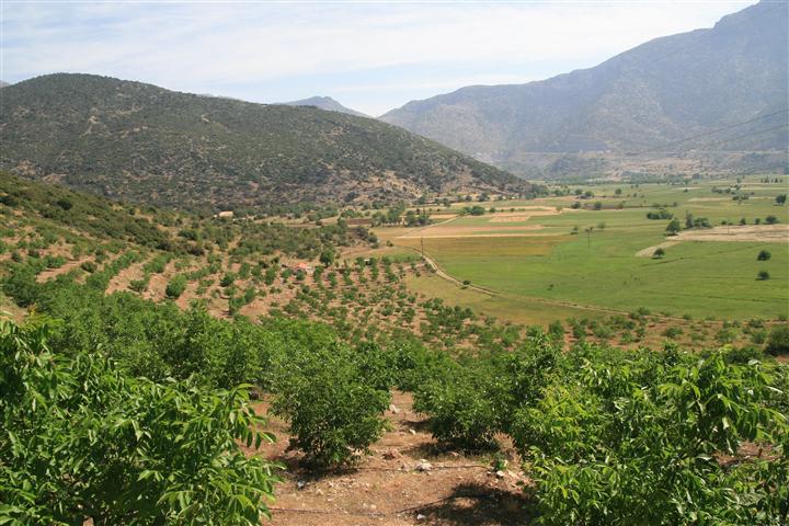
The karst basin Argon Pedion (a polje ) is a side basin with an area of approx. 4 × 2 km in the northeast of the 39 × 6 km large Tripoli plateau, which makes up a large part of the Arcadian high plateau. A narrowing of the mountains surrounding the Argon Pedion to approx. 250 m at the south end and an approx. 5 m higher passage compared to the basin floor make the basin a closed basin, i. H. only a water level of water bodies or lakes that reaches 5 m above the pool floor could lead to surface water runoff. The precipitation from the mountains first pours into the drainage ditches, but then often also over meadows and fields and wet the soil until the end of the rainy season (mostly in April / May). Depending on the amount of precipitation, there will be slight flooding. In particularly rainy winters, the flood swells to form a temporary lake that covers half or an even larger part of the basin. Since the pool floor rises very slightly from south to north, the upper part of the pool almost always remains dry. In this part, the village of Sagka in particular has always been farming.
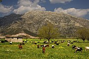
Since the soils are too wet for agricultural cultivation until the vegetation period due to the flooding, only lush grass is produced on these soils, which is well suited for grazing by herds of sheep and goats, especially since the wet grass soil is the onset of the drought delayed. Traditionally, many residents of the two villages still feed themselves with the “little man's cows”. When persistent drought causes the pastures to wither, in particular the frugal, climber-capable, weatherproof, almost anything easily digestible goats can still move to the shrubbery formation on the mountain slopes. By then at the latest, however, the danger of overgrazing is real, because the animals keep the vegetation too short by preferring to eat off shoots.
Idyllic arcadia?

Shepherd from Likouria, Achaia

Danger of overgrazing by goats


grazing_Peolonnes_Greece_Ziege.jpg)
Villages of the Argon Pedion
The photos of the traditional, beautifully walled spring water monument in Nestani and the traditional grain threshing floors in Sagka village suggest that traditional forms of society are still alive. Stylish watering holes and threshing floors are still living symbols of village identification and tradition in many villages in Greece. The villages developed through decentralized water supply (mostly since 1900) no longer need water points, just as today grain is no longer threshed in threshing areas. The photo of the spring water fountain (in Greek: φιλιππεοις Κρήνη) shows a replica that the Macedonian King Philip II, historically guaranteed by Pausanias (170 AD, see below), had built on this site in 338 BC. The circular threshing floors in the village of Sagka, in Greek: Χοροστάσι, visible in the photo, were traditionally the place where people met for the village dance after the harvest. The word Χορός (Greek for dance) is still used today for the very popular traditional Greek group dances . Any dance floor is still called Χοροστάσι in Greek (cf. en: Choros (dance) ).
The village of Nestani was characterized by pasture farming due to its location at the southern end of the basin. With the trend towards decreasing importance of agricultural use and growing urbanization and mobility, Nestani was able to hold on to the settlement of residents from Tripoli and the surrounding area.
The village of Sagka, with its proximity to (irrigated) arable farming in the upper part of the basin, traditionally focuses on agriculture, even though agriculture is only marginally profitable, even with increasing mechanization but poor transport infrastructure. On the lower parts of the slope and on alluvial soils near the village, where soils can be deeper, as in the plains, the residents of Sagka have successfully created gardens and terraces to cultivate fruit trees.

Unused irrigation well , the groundwater level can be seen
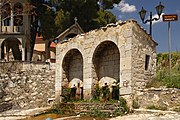
Traditional village spring in Nestani

Submarine karst spring in the Argolic Shelf Sea


Geology, hydrogeology
Geology of Greece and Peloponnese
From the large tectonic transverse zone in the Montenegrin-Albanian border area (see Skadar Lake ) the great mountain arch of the Hellenids begins , which runs over the western part of the Greek mainland, the entire Peloponnese, over the Aegean islands to western Anatolia. In the geotectonic development of the regions of Greece there were folds , ceiling movements and regional metamorphosis . In the Peloponnese, four mountain-building cycles have created the so-called “Olonos-Pindos” zone and the “Gavrovo-Tripolitza” zone, together an extensive carbonate platform. Jacobshagen emphasizes: "The Hellenids are a blanket mountain range par excellence with predominant vergences according to SW or S." There are "minimum amounts of 100 km for several blankets; [...] ".
The extensive carbonate platform determined the mountainous landscape of Arcadia and thus also the Argon Pedion side basin. Large depressions have developed between the ridges of Arcadia. Uplifts (or corresponding subsidence) and other forms of faults in the rock of the mountains and depressions have changed them in such a way that the intramontaneous depressions have become so-called “closed (karst) depressions” without surface water drainage. The Arcadian Plateau is now divided into several such closed basins.
Weathering , runoff and other forms of erosion (geology) of the surface layers have accumulated layers of loose sediment on the initially rocky basin floors . In the course of long tectonic and / or erosive processes, hard rock was shattered many times. Since the limestone is easily chemically soluble, especially in the carbonate water, an intensive karstification could develop in which the cracks gradually widened to crevices, crevices and passages. In these spaces - from the smallest pore spaces up to cavernous corridors - water could penetrate and powerful storage spaces, so-called Aquifer to develop whose water levels fluctuate depending on supply and discharge amount of stored water. In Arcadia, large subterranean waterways have been recorded along significant, proven fracture tectonics . In a large study on the basins in Arcadia it could be shown that the waterways lead mainly to the east or southeast to the Argolic Gulf. The distribution of the water in the basins, the length of time they remain underground until it emerges at often very large springs, was quantified and documented by means of coloring tests (tracing tests from 1983).
Hydrology and Morphology in Argon Pedion
Although the water from the Argon Pedion in the “Anavalos” spring near Kiveri emerges in the seawater of the Argolic Shelf Sea , it was exceptionally low-salt fresh water, and it was very well suited to be fed into the fertile lowlands of Argos via an artificial concrete channel for irrigation. It is interesting that the re-emergence of the water of the Argon Pedion in this large submarine spring (known as "your" in Pausania's time) was already assumed in ancient times.
The vital soils in the plains of the karst basins, which are important for vegetation, are fertile. They mix with loose sediments and deeper with more or less fine components such as sand and loam . Water slowly seeps into these substrates, but is also stored like in a sponge. Below that follows an irregularly thick layer of fine to finest material ( weathered components of limestone, which can be mixed with more or less high proportions of other minerals : marl , loam, clay ). These materials are water-impermeable to different degrees, so that the seepage can be delayed considerably and an “upper” water reservoir could form (visible in the scoop openings in the photo). The further infiltration into the bedrock is at least retarded (" Aquitard "). When the "upper" aquifer has reached its absorption capacity and more water is rapidly accumulating, flooding begins.
Even today, more water can accumulate in wet winters than the only katavothra located below the village of Nestani on the edge of the pool (contact of the ponor with the limestone rock) can ideally drain away quickly if it is not blocked. Then a temporary lake forms, which can last into the growing season. This phenomenon is documented for 2003, 2014 and also for March 2019. The waterway from Nestani-Katavothra to the Argolic Gulf, which is not obstructed by blockages, first transports the water to the large, submarine freshwater source "Anavalos" and later further north to Lerni and Kefalari Argos in around 190 hours.
Anthropogenic changes
The livelihood of the two villages has always been in harmony with the natural conditions of the Argon Pedion plain. The influence on the soil condition and the water availability corresponded to the possibilities on site. But gardens and terraces were successfully cultivated on the lower parts of the slope and on alluvial soils near the village, where soil conditions similar to those found on the plains are found. Here, “niche products”, e.g. B. grown from nut trees, for whose economic use the nearby motorway connection to Tripoli, Kalamata, but above all to Corinth and Athens has opened up sales markets. In the meantime, with persistence and modern cultivation methods, people are trying their hand at more common plant products - but so far these are only certain quantities for local needs. The reclamation that began about 20 years ago through the formation of terraces is an initiative of residents of the village of Sagka. You successfully run a nut plantation and promote your product, your image and your sales opportunities on a good internet platform.
The arable farming on the plain, which relied on constant care and, especially in the dry season, on irrigation, was previously supplied by bricked groundwater wells with simple pumping stations. Such wells were distributed over the whole plain. They are no longer used today and are being replaced by motorized irrigation pumps. The mechanization of agriculture is, however, not far advanced compared to the international standards of financially strong industrialized countries.
Drainage ditches crisscross the plain. They are intended to protect the soil from becoming swampy, but must also not lower the water level significantly in order to maintain the soil moisture for grazing and agriculture as long as possible. For this care, newer knowledge, modern machines and cultivation methods have been adequately applied. All the trenches lead to the only katavothra of the basin. But even today more water can accumulate than the trenches can quickly lead to the Katavothra. The areas in front of the katavothra were planted with bushes and trees and the meter-sized opening of the ponor was protected from the penetration of coarse clogging debris by a strong metal grille. The underground paths up to the re-exit at the Argolic Gulf, on the other hand, have not been changed, even today that would not be promising according to the most modern technical standards.
The construction of the Corinthos-Tripoli-Megalopoli motorway at the turn of the millennium (today up to the vicinity of Kalamata) was as careful as possible of the landscape, the basin level and the fragile hydrology. Mountain slopes were cut and the route was laid a few meters above the plain - high enough to avoid hazards from possible temporary lake formation. On a 900 m short section, however, the route cuts through part of the plain and runs on an elevated road embankment. The meandering , old drain to the Katavothra is bridged by a bridge in the road embankment.
Story (s) about the Argon Pedion
The ancient historian
The travel report of Pausanias (120–180 AD) received as text, u. a. to Arcadia, "Description of Greece" describes the ascent from Argos to the "Portitsa" pass of the Artemisio mountain range and the steep zigzag descent, which is known today as (rungs -) "Ladder of Pausanias" (Greek: Κλιμαξ Παυσανία). Pausanias even describes the descent with the detailed note: "... this descent once had artificial steps". The Argon Pedion plain and the spring well of the Macedonia King Philip are also explicitly described.
Quote:
"7. If you go over the Artemisium to M antinike, you come to the so-called lazy field, which really corresponds to its name. The rainwater that flows down from the mountains makes the plain barren, and nothing could prevent it from becoming a lake, if the water did not get lost in an opening in the earth, where it remains underground until it comes back to yours the surface is coming. Pausanias, Description of Greece, Book 8, Arcadia, 1854, p. 785 "
“To the left of the lazy field in Mantinike lies a mountain [...] and rubble from the village of Nestane, where Philip is said to have had a camp, which is why the source there is still called Philippium after him. Pausanias, Description of Greece, Book 8, Arcadia, 1854, p. 786 "
The knowledge of the hydraulics at the "Lazy Field", ie the importance of the underground connection to the submarine source "Anavalos" ("Your" in Pausanias) in the Argolic Shelf Sea, was already known in Pausanias times. The name of the level "Lazy Field" or "Argon Pedion" goes back to Pausanias.

The fertile, upper part of the Polje
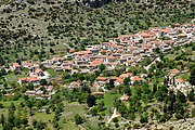
Intact traditional village of Sagka

The “ladder” of Pausanias at the Portitsa Pass


The ancient “Portitsa” pass is still a grandiose human work today: a notch that was approx. 3 m wide and up to approx. 6 m high from the foot to the top of the ridge was carved into the rock of the mountain ridge. Remnants of tracks for wagons were also found. The zigzag descent to the plain (the "ladder of Pausanias") is also partially preserved. Not only the zigzag path "Klimax", but the entire path from Argos to the great ancient cities of Mantineia and Tegea , at that time the most important connection to these cities was called Klimax. The heads of the Pausanias, the village of Sagka and the surrounding area are well documented by photos. A good, detailed description of the Portitsa and the climax descent in German and detailed photos can also be found at www.argolis.de.
The Greek geologist I. Mariolakis has published a link between the geological knowledge of the Arcadian Karst Basin and the myths of ancient Greece, and also specifically of the Argon Pedion. He was able to prove that the myths of antiquity reflect the respective hydrogeological conditions of various phenomena in the Peloponnese surprisingly well.
The rebirth of the "Arcadian Idyll"
Arcadia already received a remarkable importance through the Roman poet and epic Virgil . This transferred the idealized Sicilian peasantry to the Greek landscape of Arcadia. For him Arcadia was the land in which poetry originated and was at home. During the Renaissance , the theme of an idyllic Arcadia was “reborn” in art. Starting from Florence under Lorenzo il Magnifico, the preoccupation with antiquity flourished. The then highly influential erotic shepherd's poetry ("Bucolic poetry") by Italian artists consolidated the image of the modern era of Arcadia. Nicolas Poussin , the French and Baroque painter who lived in Rome and who was familiar with antiquity, shaped the epitome of idyll in art with his two versions of the picture “ Et in Arcadia ego ”, “I was in Arcadia too”. The phrase "Et in Arcadia ego" has been alive since the 18th century and continues to this day.
literature
- Description of Greece. Book 8: Arcadia. Translated by H. Reichardt, 7th volume, Stuttgart 1854
- Jovan Cvijić: The karst phenomenon. Try a morphological monograph. In: A. Penck (Ed.): Geographische Abhandlungen. Volume V, Issue 3, Vienna 1893
- Volker Jacobshagen (Ed.): Geology of Greece. Contributions to the regional geology of the earth. Stuttgart, 1986.
- A. Morfis (Athens), H. Zojer (Graz): Karst Hydrogeology of the Central and Eastern Peloponnesus (Greece). In: Styrian contributions to hydrogeology. Volume 37/38, Graz 1986, 301 pages. English
- Herbert Lehmann: In: F. Fuchs (Hrsg.): Karst phenomena in the northern Mediterranean area. (1973), Contributions to Karst Morphology, Herbert Lehmann; Reprint of still current articles, Stuttgart 1987
- DC Ford and PW Williams: Karst Geomorphology and Hydrology. London 1989. English
- Ilias Mariolakos: The Argon Field in Arcadia, the sinkhole of Nestani, God Poseidon and the submarine Dini Springs in the A rgolic Gulf (Peloponnisos, Greece). A geomythological approach of the Poseidon's birth. Bulletin of the Geological Society of Greece. Proceedings of the 10th International Congress, Thessaloniki, April 2004. English
- COST 621, Final Report, Groundwater Management of coastal karst aquifers, Brussels 2005. English
- J. Gunn: Encyclopedia of caves and karst Science. New York, NY, 2005. English
- A. Pentecost: Travertines. Springer-Verlag, Berlin Heidelberg 2005. English
- DC Ford and P. Williams: Karst Hydrogeology and Geomorphology. Chichester, 2007, 4th, rev. ed. English
- F. Ahnert: Introduction to Geomorphology. Aachen 2009
- H. Readers: Geomorphology. Braunschweig 2009
- Ilias Mariolakos: Geomythological Sites and Prehistoric geotechnical and hydraulic Works in Arkadia, 12th International Congress of the Geological Society of Greece, Field Trip Guide, Patras May 2010. Greek
- Hans Murawski and Wilhelm Meyer: Geological dictionary. Heidelberg, 2010, 12th edition
- K.-H. Pfeiffer: Karst, origin - phenomena - use. Stuttgart 2010
Web links
- Temporary lake, photo of the Argon Pedion, February 9, 2014 http://s2.wklcdn.com/image_21/638532/6110477/3338711Master.jpg
- Mariolakos, Geomythological Sites in Arcadia (incl. Argon Pedion) http://kpe-kastr.ark.sch.gr/site/seminars/Geomythology/GeomythologyGuide.pdf (Greek)
- Mariolakos, Geomythology of the Argon Field in Arcadia http://www.geo.auth.gr/ege2004/articles/GA1_160.pdf (English)
- Sagka Village Argon Pedion, Greece http://www.saga.gr (English, Greek)
- A prosperous nut plantation in the Argon Pedion: http://www.gvasilopoulos.gr/wp-content/uploads/2012/05/nuts-111.jpg (English)
- The “Porta Artemissiou” at the Argon Pedion http://www.argolis.de/Porta%20Artemissiou/
- The climax path to Mantineia (Οδός Κλίμαξ): http://arcadia.ceid.upatras.gr/arkadia/arcadia-hist/topics/portitsa.htm (Greek)
Individual evidence
- ↑ The Greek geologist Mariolakos describes all basin-like parts of the Arcadian high plateau and shows the connections to the local antiquity by interpreting the myths. See under web links
- ↑ See also the terrace cultivation “prosperous nut plantation” in the section on anthropogenic changes , below
- ↑ Jacobshagen, page 6
- ↑ Only the area of the prefecture of Argolida is not included in these zones. Jacobshagen, page 12
- ↑ Mesozoic and later again in the Tertiary to the Miocene
- ↑ Jabcobshagen, p 6. The quilts you have to be strong discarded imagine with mountain character formations
- ↑ Jacobshagen, page 257f
- ↑ There are also several such depressions (plateaus) in the prefecture of Corinthia , and individual depressions also in Achaia and Messenia
- ↑ On the mountain slopes with little vegetation, there were only thin editions at best
- ↑ Morfis et al., Pp. 276ff
- ↑ where it is supposed to replace increasingly salty well water
- ↑ See below on Pausanias in the Story (s) section on Argon Pedion
- ^ Ford ... Karst Hydrogeology and Geomorphology ..., p. 361ff
- ↑ See the photo in the web links: Temporary lake ...
- ↑ See the photo above: Temporary lake ...
- ↑ Geomythological Sites Mariolakos, page 16, see web links
- ↑ Cf. under left: A prosperous nut plantation in Argon Pedion
- ^ Description of Greece, Book 8, Arcadia, translated by H. Reichardt, 7th volume, Stuttgart 1854
- ↑ Pausanias, Book 8.6.4, German translation S. 785
- ^ Pausanias in the literature list
- ↑ See The climax path to Mantineia in web links
- ↑ See “Porta Artemissiou” in web links
- ↑ See the two publications by Mariolakos in web links