Etelsen
|
Etelsen
Spots long fronds
|
||
|---|---|---|
| Coordinates: 52 ° 59 ′ 43 ″ N , 9 ° 7 ′ 6 ″ E | ||
| Height : | 14 m | |
| Area : | 23.87 km² | |
| Residents : | 6847 (Dec 2011) | |
| Population density : | 287 inhabitants / km² | |
| Incorporation : | July 1, 1972 | |
| Postal code : | 27299 | |
| Area code : | 04235 | |
|
Location of Etelsen in Lower Saxony |
||
The village of Etelsen is located in Langwedel in the district of Verden in Lower Saxony (Germany).
geography
Geographical location
Etelsen is located between Bremen and Verden , approx. 25 km southeast of Bremen, in the northern Central Weser region .
Neighboring places
Neighboring towns of Etelsen are the town of Achim ( district Baden ) in the west and the district Cluvenhagen in the east .
landscape
Etelsen is located in the Weser-Aller lowland. On the southern outskirts of Etelsen the Alte Aller flows , where there is a small beach. Around Etelsen there are many fields leading through the streets, some of which are surrounded by grassland hedges . Etelsen also has two forests, one of which is adjacent to a park with a castle and a moor area. There are some independent farmers who own most of the fields around Etelsen.
history
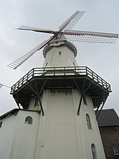
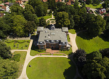
Etelsen was first mentioned in a document in 1404 and had the first farm in 1522. Around 1753 Etelsen had 28 houses, by 1855 there were already 80 houses. In the middle of the 19th century, the Hanoverian Interior Minister Johann Casper von der Wisch combined the goods Embsen, Etelsen, Koppel and Ruschbaden. The Etelsen estate also included the landscape designed into a park, today's castle park, on the hills of the Weser valley edge. In 1871 the "Jan Wind" windmill was built. In 1873 the neo-Gothic mausoleum was built in what is now the palace park; the architect and builder was Conrad Wilhelm Hase . Between 1885 and 1887, Etelsen Castle was built under the direction of the architect Karl Hantelmann in neo-renaissance style on behalf of the Heimbruch brothers. The castle was sold to the National Socialists in 1937 and served as an SA group school.
An animal park was set up in the castle park from 1960 to 1965 . There were lions, tigers, bison and many other animals there. Today's mausoleum was the former enclosure for lions, tigers and cheetahs. At that time, however, the zoo had to be closed for financial reasons. Most of the animals were either sold or, like the bison, had to be shot because they could not be captured. Another big attraction was a pond with flamingos, which is even included in a list of closed zoos by the Max Planck Institute.
The Etelser church was built in 1965 and the ev.-luth. Church congregation "To the Good Shepherd" founded. In 1968 the area of the municipality of Etelsen was enlarged to include the previously independent municipalities of Cluvenhagen and Hagen-Grinden. In 1971 Etelsen received a primary school. On July 1, 1972 Etelsen was incorporated into the spots Langwedel.
The name "Etelsen" is generally interpreted as Edelsheim (house of a nobleman).
politics
Local council
The council consists of 9 members
(As of: local election on September 11, 2011)
Subdivision
Etelsen now has over 6000 inhabitants and consists of the villages of Etelsen, Cluvenhagen and Hagen-Grinden, as well as the settlement areas Giersberg and Steinberg in the north and Lindholz in the east.
coat of arms
The coat of arms of the former municipality of Etelsen was approved in 1964 and shows a horizontally divided shield. On a silver background, two crossed, golden battle axes from the Bronze Age can be seen in the upper part, which are supposed to remind of archaeological finds in the area. In the lower part you can see three black battlements that represent the three entrenchments in the community. Furthermore, as castle battlements, they are intended to commemorate the Heimbruch family.
Life in Etelsen
Etelsen has a well-developed public infrastructure and other facilities: there are two kindergartens and a primary school, a supermarket with a drinks market, two banks, a post office, a small electrical shop, a leather factory, a small tailor's shop, three doctors, a dentist, a veterinarian, a pharmacy, a carpentry shop, two hairdressers, several restaurants and other facilities. The Waldheim Foundation is located in Cluvenhagen , where people with epilepsy, intellectual disabilities or psychological impairments live.
Culture and sights
theatre
- Etelser Schloßbühne
music
- Etelsen Gospel Choir
- Nabor (Etels rock band since 1978)
Buildings
- Etelsen Castle (1885–1887, neo-renaissance style, architect Karl Hantelmann )
- Mausoleum (1873, neo-Gothic style, architect Conrad Wilhelm Hase ) in the palace gardens
- Windmill "Jan Wind" (1871, gallery Dutchman )
Parks
- Castle park (Schlossparkverein Etelsen eV)
Regular events
- Harvest festival with harvest parade
- Castle Park Festival
- Mill Festival
- Shooting festival
- Weekly games of the 1st men, the football department of TSV Etelsen
- Every spring performances by the Etelser Schlossbühne
Economy and Infrastructure
traffic
Etelsen is on the L158 road and is close to the A 27 motorway (exit Achim -Ost and exit Langwedel-Daverden ).
Etelsen has a train station on the Wunstorf – Bremen line . However, the station building was demolished years ago for cost reasons. Local transport connections exist in the directions Verden and Bremen. In mid-December 2011 Etelsen was integrated into the network of the regional S-Bahn Bremen / Lower Saxony . Etelsen is part of the Bremen / Lower Saxony transport association (VBN)
Etelsen is a station on the Weserradweg .
Web links
Individual evidence
- ^ Federal Statistical Office (ed.): Historical municipality directory for the Federal Republic of Germany. Name, border and key number changes for municipalities, counties and administrative districts from May 27, 1970 to December 31, 1982 . W. Kohlhammer GmbH, Stuttgart and Mainz 1983, ISBN 3-17-003263-1 , p. 247 .
- ↑ www.langwedel.de accessed on June 1, 2014
- ↑ http://www.regiosbahn.de/de/fahrplan-netz/fahrplaene/fahrplaene-ab-11122011.html


