Euseigne
| Euseigne | ||
|---|---|---|
| State : |
|
|
| Canton : |
|
|
| District : | Hérens | |
| Municipal municipality : | Hérémence | |
| Postal code : | 1982 | |
| Coordinates : | 598 774 / 113355 | |
| Height : | 980 m above sea level M. | |
| map | ||
|
|
||
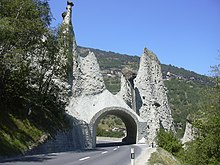
Euseigne at 970 m above sea level. M. is a district of the municipality of Hérémence in Val d'Hérens , a side valley of the Rhône in the French-speaking part of the Swiss canton of Valais . The site was known by its pyramids , an erosion phenomenon of the former medial of the after Würm receding from the deep valleys Hérens- glacier .
history
The village at the confluence of the Borgne ( Val d'Hérens ) and the Dixence ( Val d'Hérémence ), which flows into the Lac des Dix from the southwest , has been documented since the Middle Ages. The first chapel dedicated to Saint George was built by Canon Georg Dayer in 1587.
Almost the entire historical structure was destroyed by two large fires in 1800 and 1917. The chapel was renewed in 1923.
Since the middle of the 20th century, Euseigne has been a touristically relevant transit point on the approx. 30 km long route from the Rhone Valley to the glaciers at the upper end of the Val d'Hérens and to the world's highest dam, the Grande Dixence , at the end of the Val d'Hérémence . The earth pyramids of Euseigne are a distinctive stopover. In a tunnel breakthrough from 1947, the driveway leads under the formations.
Infrastructure
- Hiking trails along the Borgne up and down the valley, to Hérémence and through the Dixence valley and on the mountain ranges east of the Borgne with the neighboring communities of Mase and St. Martin .
- Branch of a side road from the main road through the Val d'Hérens into the Val Hérémence.
literature
- Béatrice Ruedin: Le paysage des pyramides d'Euseigne. In: Geographica Helvetica 18 (1963), pp. 88-90. ( Digitized version )
- Hiking map Val d'Anniviers , Val d'Hérens, Crans-Montana . 1: 60,000, Kümmerly + Frey, Bern 2006.
- Baedeker Switzerland, 9th edition 2000, p. 495 ff.
Web links
- Euseigne earth pyramids on ETHorama
- Euseigne pyramids


