Eutschütz
|
Eutschütz
Municipality Bannewitz
Coordinates: 50 ° 59 ′ 40 ″ N , 13 ° 43 ′ 40 ″ E
|
|
|---|---|
| Height : | 250 m above sea level NN |
| Incorporation : | 1915 |
| Postal code : | 01728 |
| Area code : | 0351 |
|
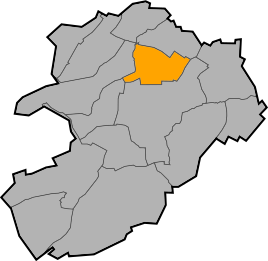
Location of Eutschütz in Bannewitz
|
|
Eutschütz is a village in the municipality of Bannewitz in the district of Saxon Switzerland-Eastern Ore Mountains , Saxony .
location
Eutschütz, part of the Bannewitz district, is located in a separate area east of the main town on the Nöthnitzbach , which flows through the Eutschützer Grund here. A few 100 meters west of the village center, through which the Eutschützer Straße runs, lies the center of Bannewitz. The Rosentitzer Straße connects Eutschütz with Nöthnitz and Rosentitz as well as Welschhufe , the Nöthnitzer Straße leads in the direction of Rippien .
history
The village was first mentioned in 1288 as "Eutschicz". The place name is of Old Sorbian origin and means "place where sheep are kept". It is unclear whether the "Oicice" mentioned in 1071 can be assigned to the village of Eutschütz - Ockerwitz is also possible . The forms “Öczschitz”, “Oschizs” and “Ötzsch” are guaranteed for the 15th and 16th centuries. The village appeared under its current name as early as 1768, but in 1835 it was referred to as "Eittzsch". In the 16th century, the village was under the Borthen manor , after which it became an administrative village. The incorporation into the neighboring Bannewitz took place in 1915. In the Breitgassendorf with its 113 hectares (status: 1900) large Gewannflur several three-sided farms were preserved. The Eutschützer watermill is now an inn.
Development of the population
|
Web links
- Eutschütz in the Digital Historical Directory of Saxony

