
Drop handle

Fallätsche is a prominent erosion funnel in the molasse rock of the Albis ridge between Uetliberg and Baldern .
topography


The case's float is on the territory of the neighborhood Leimbach ( 2 circle ) of the Swiss city of Zurich .
The field name is possibly derived from falaise ( French : steep coast ) or valláccia ( Gallo-Roman : valley-like incision ).
As a result of backward erosion, the rainbow, which measures around 400 meters in north-south direction - it extends around 200 meters down into the lower Leimbach - slowly eats its way west, so that the ridge path (~ 780 m above sea level ) has been shifted several times in the past had to become. Rock falls occur comparatively often; the last major landslide took place on May 8, 2004. The Fallätsche is the headwaters of the Rütschlibach , which flows into the Sihl at Leimbach .
geology
The steep face of the Fallätsche was formed at the end of the last Ice Age , when the Linth Glacier retreated. The erosion has exposed 300 meters of molasse sediments. The Albis chain forms the southwesternmost branch of the Hörnli fan. Its molasse was poured out by the primordial Rhine , which had absorbed all of the Graubünden spring branches since the Middle Miocene and built an extremely flat alluvial fan in the eastern Swiss Plateau.
The molasse sequence consists of many alternations of horizontally lying layers of marl, sandstone, limestone and nail flukes. In 1907 C. Escher-Hess found 24.4% limestone, 62.2% dolomite, 3.3% radiolarite, 1.5% quartzite, 1.7% reddish granite, 0.4% gneiss, under 2394 rubble on the Uetliberg , 5% quartz porphyries, 2.6% green rocks, spilites, diabase and serpentinites and 0.4% east-alpine red sandstones; 3% could not be determined. Among the limestone he found Eastern Alpine shell limestone, Partnachschichten, Arlberg limestone, Raiblerschichten, spongy limestone, nummulite limestone and yellow-brown, organism-rich sand limestone. A layer of bentonite a few centimeters thick is widespread. The swellable bentonite was created through the weathering of volcanic ash, which was spread over a large area by the wind. At the foot of the Molasse there is a horizon of bituminous marl ("stink limestone"), which at the. Smell of petroleum when smashed as they contain a lot of organic matter.
Flora and fauna
The flora of the area is extremely rich in species: In 1996, 301 vascular plants , eight ferns and 48 moss species were counted. No fewer than 74 species on the regional Red List of Threatened Species grow here, nine of which are also on the nationwide Red List.
Among the rare in Switzerland residents of the area include the dormouse and brown butterfly .
Hiking and huts
The unmarked trails (T4 – T5 on the SAC hiking scale ) on the eastern slope are considered to be quite dangerous; Careless hikers had to be rescued from the erosion funnel several times. In 2003, the REGA helicopters stationed in the lowlands did not have a winch, which is why another type had to be called in from the Alpine region for a rescue that year .
The Gratstrasse on the Albisgrat from the mountain station of the Uetlibergbahn to Baldern was originally built as a route for a railway line from the Üetliberg to the Albishorn; the project never came to fruition.
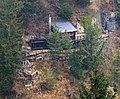
The Fallätschen area is the location of several club huts that were built in the first two decades of the 20th century when the Fallätsche was even less forested: The Bristenstäfeli , the Alpina hut , the Fallätsche tea hut of the Alpine Club , built in 1908/09, on the steep wall between Gratweg and the Manegg ruins, the Glecksteinhütte of the Amicitia Alpine Club built in 1909/10 between Gratweg and Leimbach cemetery, and the Felsenkammer Alpine Club's hut .

Bristenstäfeli

Alpina hut

Teehüsli case holder

Tea hut 1909

Glecksteinhütte
Felsenkammer hut


Landscape protection
The Albiskette and the Reppischtal were included in the federal inventory of landscapes and natural monuments of national importance (property number 1306) in 1983. Large parts of the area are forests with natural history importance (WNB) and designated as a landscape protection area.
Together with five other areas on the Uetliberg - a total of 61 hectares - the Fallätsche was included by the Zurich City Council in December 2009 in the municipal inventory of protected areas with strict requirements for use as a leisure area. A comprehensive regulation for the entire area is planned for a later date, and the expansion of the protected areas is a stated goal in order to promote biological diversity and because more and more species and ecosystems are being lost.
Web links
- Is the relic vegetation of the fall arrest endangered? Changes in flora and vegetation in an erosion funnel near Zurich ( Memento from June 19, 2002 in the Internet Archive ) (Rolf Holderegger, Elias Landolt, Ivana Stehlik, Edwin Urmi, Thomas Wohlgemuth in: Botanica Helvetica 106/2, 1996)
Individual evidence
- ↑ a b c d e The Üetliberg Lexicon ( Memento from November 6, 2008 in the Internet Archive )
- ↑ Rockslide in the Fallätsche ( Memento from August 18, 2007 in the Internet Archive )
- ^ Uetlibergverein: History of the Albiskette
- ↑ Rolf Holderegger, Elias Landolt, Ivana Stehlik, Edwin Urmi, Thomas Wohlgemuth: Is the relic vegetation of the fall arrest endangered? Changes in flora and vegetation in an erosion funnel near Zurich . In: Botanica Helvetica . tape 106/2 , 1996 ( copy of the article ( Memento of June 19, 2002 in the Internet Archive )).
- ↑ Hikr.org: Fallätsche
- ↑ Bergnot in the Fallätsche ( Memento from June 11, 2008 in the Internet Archive )
- ^ Adi Kälin: Where Zurich is wildest . In: Neue Zürcher Zeitung . No. 166 , July 21, 2015, p. 13 ( Article online [accessed July 31, 2015]).
- ↑ Why wander into the mountains ... In: Neue Zürcher Zeitung. June 22, 2009, accessed November 1, 2013 .
- ^ Bruno Weber: Alpine Club to the steep wall. Chronicle of the 100th anniversary 1906 - 2006. (PDF) Alpine Club on the steep face, accessed on April 9, 2018 .
- ↑ Again and again demolition on the Uetliberg. In: Tages-Anzeiger. January 10, 2012, accessed on November 1, 2013 : "In 1910, the Alpine Club Amicitia built the Glecksteinhütte in Fallätsche."
- ↑ Landscape development concept Adliswil - Leimbach: report with action plan . Adliswil, Zurich, 2001/2003.
- ↑ Tages-Anzeiger (December 1, 2009): Fallätsche becomes a protected area , accessed on December 1, 2009
Coordinates: 47 ° 20 '6 " N , 8 ° 30' 15.2" E ; CH1903: 680,537 / 243229