
Fallbach (Gürbe)
| Fallbach | ||
|
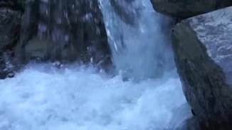
Fallbach - waterfall at the church Blumenstein |
||
| Data | ||
| Water code | CH : 470 | |
| location |
Prealps
|
|
| River system | Rhine | |
| Drain over | Gürbe → Aare → Rhine → North Sea | |
| Headwaters | prealpine in space, north of Chrumfadenflue, Stubenflue, Hohmad, Möntschelespitz 46 ° 42 '37 " N , 7 ° 28' 22" O |
|
| Source height | approx. 1800 m above sea level M. | |
| muzzle | in the Längmoos in the Gürbe coordinates: 46 ° 45 ′ 31 ″ N , 7 ° 31 ′ 1 ″ E ; CH1903: 605 993 / 178620 46 ° 45 '31 " N , 7 ° 31' 1" O |
|
| Mouth height | 616 m above sea level M. | |
| Height difference | approx. 1184 m | |
| Bottom slope | approx. 13% | |
| length | 8.9 km | |
| Catchment area | 26.1 km² | |
| Discharge at the A Eo estuary gauge : 26.1 km²
|
MQ Mq |
670 l / s 25.7 l / (s km²) |
| Left tributaries | Riedbach | |
| Right tributaries | Friedgraben | |
| Communities | Blumenstein , Pohlern , Forst-Längenbühl | |
The Fallbach is an almost nine kilometers long and right tributary of the Gürbe in the Swiss canton of Bern . It drains the northern slopes of Chrumfadenflue, Stubenflue, Hohmad and Möntschelespitz in the Bernese Pre-Alps and belongs to the catchment area of the Rhine .
geography
course
The headwaters of the Fallbach are around 1800 m above sea level. M. in the foothills of the Alps. This is where the most important spring catchments of the Blattenheid municipal association (WGB) water supply are located, with a spring rate of 1500 l / min in winter to 20,000 l / min in summer.
To the southwest above the Blumenstein church , the Fallbach forms a waterfall approx. 100 meters high.
It finally flows into the Längmoos, northeast of Mettlen at an altitude of 616 m above sea level. M. from the right in the girdle.
Its 8.9 km long run ends about 1184 meters below its source, so it has an average bed gradient of 13%.
Catchment area
The 26.1 km² catchment area of the Fallbach lies in the Gürbetal and is drained to the North Sea via the Gürbe, the Aare and the Rhine .
It borders
- in the east to that of the Walebach , which drains over the Glütschbach into the Aare
- in the southeast to that of the Feissibach , a name for the upper reaches of the Glütschbach
- in the south to that of the Buuschebach , which drains over the Simme into the Aare tributary Kander
- and to the west and northwest to that of the Gürbe.
The catchment area consists of 30.9% forest land , 53.5% agricultural area , 3.8% settlement area , 1.3% water area and 10.4% unproductive areas.

The mean height of the catchment area is 1049 m above sea level. M. , the minimum height is 615 m above sea level. M. and the maximum height at 2072 m above sea level. M.
Tributaries
The largest tributaries are the Riedbach and Friedgraben.
- Tubegrabe ( left source stream ), 1.1 km
- Lägerligrabe ( right source stream ), 1.0 km
- Chirschigrabe ( left ), 0.7 km
- Mösligrabe ( left ), 0.7 km
- Widdergrabe ( right ), 0.3 km
- Sulzgrabe ( right ), 1.8 km, 1.86 km²
- Fridgrabe ( right ), 5.2 km, 9.11 km², 230 l / s
- Riedbach ( left ), 3.7 km, 4.00 km², 90 l / s
- Mülibach ( right ), 1.1 km
Hydrology
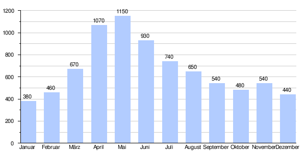
At the confluence of the Fallbach in the Gürbe, its modeled mean flow rate (MQ) is 670 l / s. Its discharge regime type is nivo-pluvial préalpin and its discharge variability is 20.
The modeled monthly mean discharge (MQ) of the Fallbach in l / s
Individual evidence
- ↑ a b c Geoserver of the Swiss Federal Administration ( information )
- ↑ Water network in the WebGis geographic information system of the canton of Bern
- ↑ a b Modeled mean annual discharge. In: Topographical catchment areas of Swiss waters: area outlets. Retrieved November 2, 2015 .
- ↑ Archived copy ( memento of the original from July 17, 2012 in the Internet Archive ) Info: The archive link was inserted automatically and has not yet been checked. Please check the original and archive link according to the instructions and then remove this notice. Blattenheid headwaters
- ↑ Topographic catchment areas of Swiss waters: Fallbach
- ↑ Swisstopo
- ^ Main hydrological strand
- ↑ "Hidden behind the mean values" - the variability of the discharge regime , p. 119
- ↑ The discharge variability describes the extent of the fluctuations in the mean discharge of individual years around the long-term mean discharge value.