
Ferlacher Horn
| Ferlacher Horn (Gerloutz) | ||
|---|---|---|
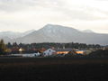
 Ferlacher Horn of the Hollenburg seen from |
||
| height | 1840 m above sea level A. | |
| location | Carinthia , Austria | |
| Mountains | Karawanken , Karawanken and Bacher Mountains | |
| Dominance | 5.5 km → Loibler Baba | |
| Notch height | 665 m ↓ donkey saddle | |
| Coordinates | 46 ° 29 '12 " N , 14 ° 18' 51" E | |
|
||
| rock | Wetterstein lime | |
| Age of the rock | Ladinium - Carnium | |

The Ferlacher Horn (also called Gerloutz , Slovene : Grlovec ) rises to a height of 1840 m above sea level. A. very striking in the south of Ferlach . The Ferlacher Horn is clearly visible from the Carinthian state capital Klagenfurt . The Ferlacher Horn is part of the Karawanken . As is often the case in these mountains, the Ferlacher Horn is characterized by steep demolition zones in the north, but by forest in the south and - only at the very top below the summit - by grass cover.
The Ferlacher Horn is home to numerous legends - ghosts, ghosts, even the Saligen women are said to frighten hikers and lead them astray. From the summit there is a wonderful panoramic view of the cities of Ferlach and Klagenfurt , the Drau , which winds through the Rosental , and the Karawanken , especially the Koschuta , the group around the high chair , and the Hochobir .
Surname
The name "Ferlacher Horn" was introduced in 1909 by the German and Austrian Alpine Association as the best possible Germanization [of the Slovenian name] , sometimes literally a little different, but adapted to the German language feeling, along with numerous other new German field names for the high chair and Koschuta area of the Karawanken. The Slovenian form of the name Grlovec is based on grlo "throat, throat" and refers to the steep northern slopes.
Ascents
The Südalpenweg leads in an east-west direction over the summit.
A multitude of climbs is given to the hiker. What they all have in common is that they are generally harmless, but quite tedious. Due to the low summit height and the thick forest, the Ferlacher Horn is also accessible in winter. There are no refuges on the Ferlacher Horn.
- From Waidisch: The path from Waidisch is marked with yellow signs. Duration: approx. 3 to 3½ hours.
- Von Ferlach / Schaida-Bauer: This path, known as the Raketensteig, is very steep and difficult, but there are no exposed areas. You start directly in Ferlach at Gasthof Schaidabauer and reach the summit after approx. 4 hours.
- From Zell-Winkel / Franzi-Bauer: The shortest ascent from the Franzi-Bauer only takes about 2½ hours.
- From Loibltal / Gasthof Deutscher Peter (approach from Klagenfurt to the Loiblpass ): Over the Eselsattel ⊙ you meet the path from Franzi-Bauer and after about 3½ hours you reach the summit.
Photo gallery

View from the Lausegger mountain inn to the Ferlacher Horn

Ferlacher Horn, seen from Tentschach Castle

Ferlacher Horn with railway line north of Maria Rain
Ferlacher Horn as seen from Klagenfurt

View from the Bodental to the Ferlacher Horn

View from the summit to Ferlach, the Drau, Klagenfurt

Summit cross of the Ferlacher Horn


literature
- Manfred Posch : The magic kingdom of Karawanken. The most beautiful tours, Klagenfurt 1997, Kärntner Druckerei- und Verlagsgesellschaft mbH; ISBN 3-85391-143-9
Web links
Individual evidence
- ↑ Communications of the German and Austrian Alpine Club , Volume 35, Munich-Vienna 1909, p. 111.
- ^ Heinz-Dieter Pohl : Mountain names in Austria