Reuberg
| Reuberg | ||
|---|---|---|
| Highest peak | Main summit of the ridge ( 328.2 m above sea level ) | |
| location | Districts of Holzminden and Hildesheim in Lower Saxony ( Germany ) | |
| part of | Lower Saxony highlands | |
|
|
||
| Coordinates | 51 ° 58 ' N , 9 ° 47' E | |
| Type | Low mountain range | |
The Reuberg is up to 328.2 m above sea level. NN high ridge of the Lower Saxony mountains in the districts of Holzminden and Hildesheim in Lower Saxony ( Germany ).
Geographical location
The Reuberg is located in the western part of the Leinebergland , a northern part of the Lower Saxony mountains . It stretches for about 3.5 km in the triangle between the villages of Alfeld , Delligsen and Duingen . It lies between Brunkensen in the north, Warts in the east, Gerzen in the southeast, Grünenplan a little further away in the east-southeast, Hohenbüchen in the west and the somewhat distant Coppengrave in the northwest.
The Duinger Berg extends northwest of the Reuberg , the Külf to the north , the Seven Mountains to the east, the Steinberg to the southeast , the Hils ridge to the southwest and the Ith , which is partly part of the Weserbergland Schaumburg-Hameln Nature Park . The valley of the Glene , a southwest tributary of the Leine , leads over to the Duinger Berg.
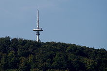
On the main summit of the Reuberg ( 328.2 m above sea level ) stands the Gerzen telecommunications tower ⊙ of Deutsche Telekom . The Lippoldshöhle and the Gleneburg cultural monument are located on the northwestern slope of the ridge . The B 3 passes the Reuberg a little to the east .
Geology and landscape
The Reuberg is a fold of Thüster limestone . On its partly steeply sloping flanks there are limestone cliffs, mostly hidden in the forest , like those in the southeast on the main crest.
The Reuberg is dense in particular from deciduous forest.
hike
Several forest trails and paths lead across the Reuberg, including a hiking trail over the ridge of the ridge from the Glene valley to Warzen. The European long-distance hiking trail E11 leads south-east in the transition area to Steinberg between Grünenplan and Gerzen .

