
Filzmoos (Hebalm)

The Filzmoos is a wetland on the Hebalm in the Middle Koralpe in western Styria .
geography

The Filzmoos is located in the eastern part of the Freiländer Alm on the Hebalm at an altitude of 1450 m above sea level. A. , approx. 2 kilometers (coordinates above right) east of the Hebalmstraße (Rehbockhütte, Hebalmwirtshaus) and north of the Schwarzkogel . It is part of an approx. 1 km² large, remote and difficult to penetrate area, in which small forest areas alternate with bush zones, sometimes mountain pines and waterlogged areas , moors and swamps . The area can be reached on foot on farm roads (closed for cars), access to the Freiländer Almhütte is possible (only managed in summer, gravel road only recommended for cars without spoilers or with a high wheelbase).
Filzmoos is located on property no. 169/2 of the cadastral community of Klosterwinkel . The property numbers in the property cadastre , which document the various types of use (see picture) at the beginning of the 19th century, are no longer up-to-date for this area.
The location of the Filzmoos on the ridge of the Koralpe is evidence of the clod-like structure of this mountain range: the Koralpe is geologically an uplifted part of the mountain, a so-called Pultscholle . The wetland is located on a relatively flat area several kilometers long, on which there are a number of wetlands (including the See Eben ).
The subsoil of the Filzmoos consists of a water-impermeable rock layer that is heavily interspersed with mica (gneiss mica schist ).
The Filzmoos rises in a westerly direction from the Rettenbach , east from the Klosterbach and in the north with the Stering Bach , which flows through the former Grandner Alm, a source brook of the Packer Bach.
Surname
The part of the name “felt” can also mean areas that are densely overgrown with moss. This means that the name “Filzmoos” has a double definition. This may be due (see pleonasm ) that the present here old meaning of "felt" kicked over time into the background or was ever forgotten and should clarify the word "moss" also used that the word is not the textile felt , but the wet area was meant.
environment

The Filzmoos is a saddle moor . Such moors arise from swamps of flat transitions between mountain heights, here the saddle between Schwarzkogel and Münzerkogel. Most of the raised bog rests directly on the mineral subsoil. This rare type of bog is usually located directly on the watershed, and forms headwaters at the edges. This is also the case with Filzmoos. At the same time, it is a raised bog (rain bog ), which means that the moisture does not come from the slopes above, but is primarily moistened from precipitation.
Characteristic of Filzmoos are the small open areas between the trees that are overgrown with cotton grass . In the drier parts of the area that are still grazed, the lime-hostile Bürstling that grows on poor soil is widespread. In the area there is also the Birkenkögerl , once a rock formation with a solitary birch, but which is forested. The status of a natural monument was lifted in 2010.
The Filzmoos was declared a nature reserve Freiländer Filzmoos in 2010 ; it had been a protected part of the landscape since 1967. This protection serves to preserve the raised bog and the stock of laying pines in this area. Any change in the water balance and the soil design, afforestation and the removal of laying pines and mosses are prohibited. Only the spruce stands may be used.
Filzmoos is located in the southwest of the Pack – Reinischkogel – Rosenkogel conservation area .
history
The age of a piece of wood recovered in 1973 from the peat of the Filzmoos at a depth of approx. 3.05 to 3.15 m (location of the sampling) was determined by a radiocarbon test at 7000 ± 120 years. The time in which this piece died is around 5030 BC. So it is definitely a post-glacial primary bog that began to form soon after the glaciers retreated during the last ice age.

photos
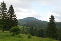
Over the Filzmoos on the way to the Schwarzkogel

The Filzmoos can be reached via the Freiländer Almhütte.

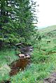
Source stream of the Rettenbach
The watercourses from the Filzmoos are part of the water supply for the meadows of the Freiländer Alm
In Filzmoos

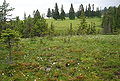
Cotton grass meadow


Individual evidence
- ↑ Land register 61027 Klosterwinkel, District Court Deutschlandsberg, insert number 19.
- ↑ gray = forest, green = meadow, scrub, light yellow = unproductive. MH = middle wood, SH = pole wood
- ↑ Arthur Winkler-Hermaden a. a .: Scientific study results of the working group for geological-pedological investigations in the catchment area of the Laßnitz river in south-western Styria. Austrian Academy of Sciences, mathematical and natural science class, Dept. I, 149. Issue 7-10, pages 225-226. Vienna. Peter Beck-Managetta: About the geological structure of the Koralpe. In: G. Weissensteiner: Mineralien der Koralpe . 1. Special volume of the club magazine Die Eisenblüte . Association of Styrian Mineral Collectors, Graz 1979. Page 6.
- ^ Geological map of the Republic of Austria 188 Wolfsberg. Published by the Federal Geological Institute, Vienna 1980.
- ↑ " ... in the Bohemian Forest and in Bavarian regions densely overgrown with mosquitos, the names filz m. or felt f., for example sea felt, dwarf birch felt, Kolber felt, Elmoser felt, ... “: Jakob and Wilhelm Grimm: German dictionary . Volume 3 E-Research. Leipzig 1862. Keyword “felt”, point 2). Column 1632 Z 16. Reprint from Deutscher Taschenbuch Verlag. Munich 1991. dtv 5945. ISBN 3-423-05945-1 . Structure quoted from: The digital Grimm-electronic edition of the first processing. Version 12/04. Verlag Zweausendeins, Frankfurt am Main. Competence center for electronic cataloging and publication processes in the humanities at the University of Trier in conjunction with the Berlin-Brandenburg Academy of Sciences. ISBN 3-86150-628-9 .
- ↑ Gert Michael Steiner, Christian Keusch. University of Vienna, departments for nature conservation biology, vegetation and landscape ecology. Vienna Ecology Center. Institute of Ecology and Conservation Biology: Website Moore ( page can no longer be accessed , search in web archives ) Info: The link was automatically marked as defective. Please check the link according to the instructions and then remove this notice. .
- ↑ Ordinance of the district captain of Deutschlandsberg on the declaration of the moor "Freiländer Filzmoos" as a nature reserve. Grazer Zeitung year 2010, pp. 458–459, in force from August 28, 2010. Index of Styrian regional law 5500/02/240. The ordinance of the District Commission of Deutschlandsberg from November 21, 1967, GZ: 7 K 2/9 66, on the declaration of the “Legföhren population on the Freiländer Alm” as a protected part of the landscape , which had been in force until then , was thus suspended.
- ↑ Landscape protection area 02: Ordinance of the Styrian state government of May 25, 1981 , stmk. State Law Gazette No. 37/1981 as amended (new map display) No. 64/1981: Map of the protected area ( Memento of the original of December 21, 2007 in the Internet Archive ) Info: The archive link was inserted automatically and has not yet been checked. Please check the original and archive link according to the instructions and then remove this notice. in the Digital Atlas Styria.
- ^ Heinz Felber, Institute for Radium Research and Nuclear Physics of the Austrian Academy of Sciences, Vienna: Vienna Radium Institute Radiocarbon Dates VI. In: Radiocarbon, Vol. 17, No. 2, 1975, pages 247-254. Sample No. VRI-388.
Web links
Coordinates: 46 ° 54 ′ 50 ″ N , 15 ° 4 ′ 10 ″ E