Flaugnac
| Flaugnac | ||
|---|---|---|
|
|
||
| local community | Saint-Paul-Flaugnac | |
| region | Occitania | |
| Department | Lot | |
| Arrondissement | Cahors | |
| Coordinates | 44 ° 17 ′ N , 1 ° 24 ′ E | |
| Post Code | 46170 | |
| Former INSEE code | 46103 | |
| Incorporation | January 1, 2016 | |
| status | Commune déléguée | |
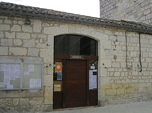
 Flaugnac Town Hall |
||
Flaugnac ( Occitan : Flaunhac ) is a village and a commune déléguée in the southern French municipality of Saint-Paul-Flaugnac with 408 inhabitants (as of January 1, 2017) in the Lot department in the Occitania region . The inhabitants are called Flaugnaciens .
The municipality of Flaugnac merged with Saint-Paul-de-Loubressac to form the Commune nouvelle Saint-Paul-Flaugnac on January 1, 2016 and has since held the status of a Commune déléguée. It belonged to the arrondissement of Cahors and the canton of Marches du Sud-Quercy (until 2015: canton of Castelnau-Montratier ).
location
Flaugnac is located on the banks of the Lupte River in the old cultural landscape of the Quercy , about 30 kilometers north of Montauban . The Barguelonne delimited the municipality to the northwest. The municipality of Flaugnac was surrounded by the neighboring municipalities of Pern in the north, Saint-Paul-de-Loubressac in the east and Castelnau-Montratier in the south and west.
The former Route nationale 659 (today's D659) leads through the Commune déléguée .
Population development
| year | 1962 | 1968 | 1975 | 1982 | 1990 | 1999 | 2006 | 2012 |
| Residents | 497 | 445 | 381 | 389 | 376 | 380 | 405 | 427 |
| Source: Cassini and INSEE | ||||||||
Attractions
- Dolmen La Lécune
- historical town center
- Saint-Vincent church from 1861
Personalities
- Bérenger de Roquefeuil (1448–1530), nobleman, lord of Castelnau-Montratier

