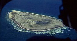
Tromelin Airfield
| Tromelin Island Airstrip | |
|---|---|

|
|
| Characteristics | |
| ICAO code | - |
| IATA code | - |
| Coordinates | |
| Height above MSL | 6 m (20 ft ) |
| Transport links | |
| Distance from the city center | 1 km south of Tromelin Island weather station |
| Basic data | |
| opening | 1954 |
| operator | TAAF |
| Start-and runway | |
| Airstrip | 1000 m earth |
The airfield Tromelin is located on the French island of Tromelin in the French Southern and Antarctic Territories (TAAF).
It was built in 1954 for the weather station on the island of Tromelin and has been used ever since to bring the station staff to and from the island. The airport is not part of the EU and the Schengen Agreement .
Individual evidence
- ^ Tromelin Island Airstrip. (No longer available online.) In: www.askdatas.com. Archived from the original on November 10, 2016 ; accessed on November 10, 2016 . Info: The archive link was inserted automatically and has not yet been checked. Please check the original and archive link according to the instructions and then remove this notice.
- ↑ airport24: Tromelin Island Airstrip. October 30, 2016. Retrieved October 30, 2016 .