Fort Denaud
| Fort Denaud | ||
|---|---|---|
|
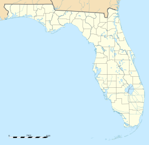
Location in Florida
|
||
| Basic data | ||
| State : | United States | |
| State : | Florida | |
| County : | Hendry County | |
| Coordinates : | 26 ° 45 ′ N , 81 ° 28 ′ W | |
| Time zone : | Eastern ( UTC − 5 / −4 ) | |
| Residents : | 1,694 (as of 2010) | |
| Postal code : | 33935 | |
| Area code : | +1 863 | |
| FIPS : | 12-23730 | |
| GNIS ID : | 2583343 | |
Fort Denaud is a census-designated place (CDP) in Hendry County in the US state of Florida with 1,694 inhabitants (as of 2010).
Demographic data
According to the 2010 census, the 1694 inhabitants at that time were distributed over 877 households. 89.5% of the population identified themselves as whites , 1.2% as African American , 0.5% as Indians and 0.5% as Asian Americans . 6.3% said they belonged to another ethnic group and 2.0% to several ethnic groups. 13.2% of the population were Hispanics or Latinos .
In 2010 children under the age of 18 and 43.4% of all households lived in 27.7% of all households with persons at least 65 years of age. 74.8% of households were family households (consisting of married couples with or without offspring or one parent with offspring). The average household size was 2.51 people and the average family size was 2.88 people.
22.0% of the population were younger than 20 years, 19.2% were 20 to 39 years old, 25.6% were 40 to 59 years old, and 33.3% were at least 60 years old. The mean age was 48 years. 49.8% of the population were male and 50.2% were female.
The median annual income was $ 75,982, with 0.9% of the population living below the poverty line.
Individual evidence
- ^ Profile of General Population and Housing Characteristics: 2010 . United States Census Bureau . Retrieved April 10, 2013.


