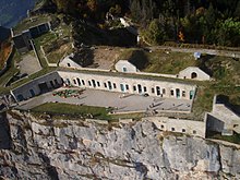
Fort du Saint-Eynard
The Fort du Saint-Eynard is a 19th century fortification in the Isère department in France , which is part of the fortress belt around Grenoble .
location
The fort is located on Mont Saint- Eynard, named after the Carthusian monk St. Eynard, near its summit on the border of the communes of Le Sappey-en-Chartreuse and Corenc at an altitude of 1,338 m, above a steep slope sloping to the southeast. To the northwest it is protected by a cut in the terrain. The access road is closed to vehicle traffic in winter.
history
Political tensions between France and first the Kingdom of Sardinia , then the newly founded Kingdom of Italy in 1870 led to the construction of several fortifications on the French side, including the fortress belt around Grenoble. This was included in the fortification system of General Séré de Rivières and implemented under Colonel Cosseron de Villenoisy. After preliminary studies in 1872 and 1873, the construction of the Fort du Saint-Eynard was approved in October 1874, started in June 1875 and finished in October 1879. For this purpose, 27.44 hectares of land were purchased and divided into three zones with increasing usage restrictions towards the fort. Many workers were of Italian origin. Between 1892 and 1903, photographs of the fort were taken from tethered balloons .
The fort was designed for a garrison of 436 soldiers, 26 NCOs and 15 officers and was initially equipped with 19 guns and six mitrailleuses . The communication between the forts of the belt around Grenoble and with other systems in south-east France was initially used by optical telegraphs .
The fort's tasks were to defend the access to Grenoble through the Chartreuse and guard the Col de Porte, an important mountain pass on the road from Savoy (today's D512), but there was no fighting in its vicinity during World War I , and its guns were sent to the front. After the First World War, the garrison was greatly reduced and the fort almost disarmed.
Around 1930 a material ropeway to the Col de Vence was built by engineering troops . During the Second World War , the fort was occupied by Italian troops after the armistice in 1940, handed over to the Vichy regime in 1942 and occupied by German troops after the Allied landing in Italy in 1943. Since it had become obsolete in the meantime, it was abandoned after the Second World War and sold to the neighboring communities in 1963. From 1991 to 1995 most of the buildings were secured and renovated. Today the fort houses a restaurant, exhibition and meeting rooms and is open to visitors from May 1st to November 1st.
buildings
The three connected main buildings with crew and officers quarters, storage rooms for ammunition and food, kitchen, bakery and infirmary are made of ashlar masonry with vaults . The powder chambers were carved into the rock.
Web links
- Fort Saint-Eynard ( French ) Retrieved November 17, 2015. Presentation by the Fondation du Fort Saint Eynard
Coordinates: 45 ° 14 ′ 7 ″ N , 5 ° 45 ′ 46 ″ E
Individual evidence
- ↑ P. de Farconnet: Saint Eynard et l'ermitage de Faissia . Fort Saint Eynard Foundation.
- ↑ Jean Azeau: Les Forts de grenoble du XIX ème siècle . Fort Saint Eynard Foundation. Retrieved November 17, 2015.
- ↑ a b c plan planches, Garrison, dotations ... . Fort Saint Eynard Foundation. Retrieved November 17, 2015.
- ^ Serge Pivot: Continuing "Télégraphe optique" . Fort Saint Eynard Foundation. Retrieved November 17, 2015.
- ↑ a b Jean Azeau: Le fort du Saint-Eynard . Fort Saint Eynard Foundation. Retrieved November 17, 2015.
- ↑ Nous Rejoindre . Fort Saint Eynard Foundation. Retrieved November 17, 2015.
- ↑ Les Poudrières . Fort Saint Eynard Foundation. Retrieved November 17, 2015.


