Frankholz (Beek)
|
Frankholz
Im Frankholz City of Wuppertal
Coordinates: 51 ° 15 ′ 58 " N , 7 ° 5 ′ 42" E
|
||
|---|---|---|
| Height : | 211 m above sea level NHN | |
|
Location of Frankholz in Wuppertal |
||
|
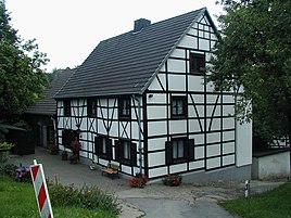
Half-timbered courtyard building in Im Frankholz
|
||
Frankholz , also Im Frankholz , is a farm in the northwest of the Bergisch city of Wuppertal on the upper reaches of the Steinberger Bach .
Location and description
The courtyard is located at an altitude of 211 m above sea level. NHN on a branch path of Pahlkestraße , a high path that was previously a regionally important coal path, in the northwest of the residential district of Beek in the Uellendahl-Katernberg district . Neighboring locations are Frankholzhäuschen , Frankholzhöhe , the riding center Katernberg , Häuschen , Lohrenbeck , Gut Steinberg , Eskesberg , Bergerheide , Kutenhaus , König and Am Hagen .
In addition to the called Frank Wood farmstead about 250 meters there is south facing second living space Frank Wood .
Etymology and history
While the part of the name Holt , wood clearly denotes a forest, the meaning of Frank is not clear. The naming after the tribe of the Franks or an early owner with the name Franco seems questionable . Frank likely timber is a derivative of Wrankholz (= Streitholz , controversial forest ).
An early documentary mention of this Frankholz took place as early as 1400 as Niederes Frankholz . It is unclear whether the two Frankholz farms were an undivided estate before 1400 and one Frankholz split off from the other, or whether they were independent living spaces that got their common name from the hallway designation. At that time one or both farms belonged to a farm association of Werden Abbey under the Oberhof Kalkofen.
In the early modern period Frankholz belonged to the parish of Sonnborn in the Bergisch Amt of Solingen . The farm is listed as Franckholt on the Topographia Ducatus Montani by Erich Philipp Ploennies from 1715. On the topographical survey of the Rhineland from 1824, the living space is recorded as Im Frankholz , as well as on the Sonnborn community map from 1868. It is recorded as Frankholz I in the Wuppertal city map from 1930.
The two Frankholz were located in the municipality of Sonnborn , which was split off from the mayor's office in Haan in 1867 and which was renamed the municipality of Vohwinkel in 1888 with the transfer of territory to the city of Elberfeld .
In the municipality lexicon for the Rhineland province of 1888, five houses with 67 inhabitants are given for both Frankholz.
With the founding of Wuppertal in 1929, the two Frankholz were accepted into the city area as part of Vohwinkel.
Individual evidence
- ^ Wolfgang Stock: Wuppertal street names. Their origin and meaning. Thales Verlag, Essen-Werden 2002, ISBN 3-88908-481-8
- ↑ Wilfried Heimes : The beginnings of the district Sonnborn in the Bergisches Land and their development - a settlement geographic study , Cologne 1961 (Cologne, University, phil. Inaugural dissertation of December 14, 1961).
- ^ Hermann Kießling: Courtyards and farm associations in Wuppertal. Bergisch-Märkischer Genealogischer Verlag, Wuppertal 1977.
- ↑ Königliches Statistisches Bureau (Prussia) (Ed.): Community encyclopedia for the Rhineland Province, based on the materials of the census of December 1, 1885 and other official sources, (Community encyclopedia for the Kingdom of Prussia, Volume XII), Berlin 1888.

