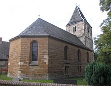
Göthewitz
Göthewitz is part of the Muschwitz district of the city of Lützen in the Burgenland district in Saxony-Anhalt .
geography
Göthewitz is located southeast of Lützen between Leipzig and Weißenfels . The village is surrounded by extensive agricultural land. The Grünebach flows north-east of the village, behind which lies the center of Muschwitz.
Wuschlaub is located southeast of Göthewitz.
The A 38 passes north of Göthewitz .
history
Göthewitz was located on the north-eastern edge of the administrative district of Weißenfels (Kreischau: Burgwerben court seat, Göthewitz and Wuschlaub: Mölsen court seat), which belonged to the Secondogenitur Principality of Saxony-Weißenfels between 1656/57 and 1746 .
As a result of the resolutions of the Congress of Vienna , the Weißenfels office came to the Kingdom of Prussia in 1815 and was assigned to the Merseburg administrative district of the province of Saxony in 1816. Göthewitz came to the Weißenfels district .
During the first district reform in the GDR, Göthewitz was incorporated into the Muschwitz community on July 1, 1950. With the second district reform on July 25, 1952, Muschwitz came to the Hohenmölsen district in the Halle district , which in 1994 in the Weißenfels district and this in turn in 2007 in the Burgenland district.
On January 1, 2010, the previously independent communities of Muschwitz, Großgörschen , Poserna , Rippach and Starsiedel merged with the city of Lützen to form the new city of Lützen.
Attractions
- church
- Manor
Personalities
- Christian Kramer (* 1983), triathlete
Web links
Individual evidence
- ^ Karlheinz Blaschke , Uwe Ulrich Jäschke : Kursächsischer Ämteratlas. Leipzig 2009, ISBN 978-3-937386-14-0 , p. 36 f.
- ^ The place in the book "Geography for all Stands, p. 374f.
- ^ The district of Weißenfels in the municipality register 1900
- ↑ Muschwitz and its districts on gov.genealogy.net
- ↑ StBA: Area changes from January 01 to December 31, 2010
Coordinates: 51 ° 11 ′ N , 12 ° 7 ′ E

