Garibaldi Provincial Park
|
Garibaldi Provincial Park
|
||
|
Mount Garibaldi |
||
| location | British Columbia (Canada) | |
| surface | 1,946.5 km² | |
| WDPA ID | 4179 | |
| Geographical location | 49 ° 55 ' N , 122 ° 45' W | |
|
|
||
| Setup date | 1927 | |
| administration | BC parks | |
The Garibaldi Provincial Park is a 1,946 square kilometer provincial park in the Canadian province of British Columbia . The park is 40 miles north of Vancouver and protects an impressive stretch of the Coast Mountains .
investment
The small park is located in the transition area between the Sunshine Coast and the Coast Mountains. Access to the park is via various parking lots along the Sea-to-Sky-Highway or from Alice Lake Provincial Park . The park is no longer accessible by roads.
The park is a category II protected area ( national park ).
history
Mount Garibaldi was first climbed in 1907. The view and the beauty of the surroundings led to regular mountaineering camps at Garibaldi Lake in summer, so that as early as 1920 the area was classified as a Park Reserve . In 1927 the Provincial Park was established with a size of 194,650 hectares and named after Mount Garibaldi.
geography
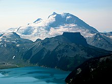
The mountains were built up by volcanic activity and shaped by glaciers. Their erosion processes created bizarre mountain formations, deeply cut valleys and mountain slopes rich in rubble. The Mount Garibaldi itself is a 2,678 m high stratovolcano . The region between the Garibaldi Glacier and the Cheakamus Lake in particular is characterized by the alternation of black volcanic mountains, snow-glistening glaciers and deep blue mountain lakes.
When Mount Price erupted 10,000 years ago, a glacier stopped the flowing lava and created a natural dam, which is still 460 meters high today and is called The Barrier . The Barrier dams Rubble Creek to almost 10 square kilometers and up to 300 meters deep Garibaldi Lake . An earthquake in 1855 caused the western part of the barrier to plunge into Rubble Creek as a rock avalanche, the landslide is still visible today. The Table rises south of Lake Garibaldi , a steep-walled and plateau-like summit , 2019 m high. It was created when lava erupted under the glaciated peak and melted a channel into the ice. This gave the mountain top the shape of a layer cake, a phenomenon that is otherwise only known in two other places worldwide.
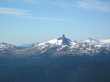
The Black Tusk north of Garibaldi Lake is the 2319 m high chimney of a volcano that was filled with hard basalt. The outer, softer shell of the volcano was removed by erosion, so that today only a black basalt cylinder rises from the rubble-strewn ridge. The highest mountain in the park is the 2,891 m high Wedge Mountain in the north of the park.
Flora and fauna
Within the ecosystem of British Columbia, the park area is assigned to different zones due to their size and nature, the Coastal Western Hemlock Zone , the Mountain Hemlock Zone and the Alpine Tundra Zone . While the Alpine Tundra Zone can be clearly identified from an altitude of 1750 meters, the transition from the Mountain Hemlock Zone below to the Coastal Western Hemlock Zone is fluid. These biogeoclimatic zones are characterized by the same or a very similar climate and the same or similar biological and geological conditions. This results in a very similar population of plants and animals in the respective zones.
There are several levels of vegetation in the park area: in the valleys and on the lower mountain slopes, especially in the western Cheakamus Valley , there is a humid rainforest made up of West American hemlocks , Nootka cypresses and Douglas firs . The trees, which are up to 400 years old, are up to 60 meters high and up to nine meters in circumference. The forest has a dense undergrowth of sword ferns , heather plants and evergreen blueberries . Epiphytic lichens and mosses cover every tree trunk up to the crown. From an altitude of 1000 meters, the rainforest becomes a mountain forest dominated by spruce and consisting of rocky mountain firs with an undergrowth of an impenetrable thicket of willow, red elder , black raspberries and white rhododendron . On the plateau-like mountain slopes, the mountain forest changes into sub-alpine flower meadows, which are covered by an extremely rich bloom from June. The first bloom consists of wood anemones , snow buttercups , daffodils and mountain lilies . A second flowering of Indian Paintbrush , Canadian Fleabane , Arctic Lupine , Arnica , Narrow-leaved Willowherb and Green Germer follows in August .
From an altitude of 1500 meters, black rubble fields largely devoid of vegetation cover the mountain slopes, which rise to snow fields and glaciers. Here you will find almost only lichens, such as map lichen and similar plants.
Mammals include black bears , mountain goats , ice gray marmots , whistle hares , snowshoe hares , ground squirrels and chipmunks . Golden eagles , red-tailed buzzards , corner- tailed corsair and bald eagles come to the park to search for prey in late summer.
activities
The park is a popular destination for hikers, mountaineers and other outdoor sports enthusiasts. It offers a variety of hiking options, from half-day hikes to multi-day hiking tours. The park itself can only be reached on foot, there are no roads within the park boundaries. Only several simple tent sites and shelters offer overnight accommodation. Ranger stations are located at Garibaldi Lake and in the Diamond Head area . Paths lead into the park from five points on Sea-to-Sky-Highway 99 . The first access to the park is behind Squamish on Howe Sound. From here you can reach the Diamond Head area with Elfin Lake via the Elfin Lake Trail . This is followed by the access to Garibaldi Lake, then the path to Cheakamus Lake. From Whistler a trail leads to Singing Pass and further on the road to Pemberton there is a turnoff to Wedgemount Lake . Apart from these five regions, the park is not accessible as a wilderness to protect the natural ecosystem. The park is covered with a thick blanket of snow from November to mid-June. The Diamond Head area is then a destination for ski tourers . At the northern boundary of the park is Whistler Mountain , 2181 meters high , but its ski area is no longer part of the park.
literature
Peter Mertz: Travel Guide Nature Canada. Munich: BLV, 1996, ISBN 3-405-14817-0
Web links
- Garibaldi Provincial Park . In: BC Geographical Names (English)
- Garibaldi Provincial Park . In: English language website of the park at BC Parks
- Garibaldi Provincial Park ( English, French ) In: The Canadian Encyclopedia .
- www.garibaldipark.com - Private homepage with hiking information
- Information to the park on britishcolumbia.com (Engl.)
Individual evidence
- ↑ World Database on Protected Areas - Garibaldi Park (English)
- ^ Garibaldi Provincial Park - Master Plan. (PDF; 3.5 MB) British Columbia Ministry of Environment, Lands and Parks , September 1990, accessed on January 3, 2013 (English).
- ^ Ecosystems of British Columbia. (PDF; 10.31 MB) British Columbia Ministry of Forests, Lands and Natural Resource Operations , February 1991, accessed on January 3, 2013 .
- ↑ Biogeoclimatic Zones of British Columbia. British Columbia Ministry of Forests, Lands and Natural Resource Operations, accessed May 3, 2016 .


