Gash (Valbona)
|
Gash Lumi i Gashit |
||
|
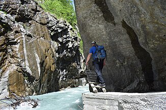
Footbridge in a narrow part of the gorge |
||
| Data | ||
| location | Albania | |
| River system | Buna | |
| Drain over | Valbona → Drin → Buna → Adria | |
| source | Mountain lakes near Dobërdol | |
| muzzle | in the Valbona coordinates: 42 ° 22 ′ 37 " N , 20 ° 5 ′ 47" E 42 ° 22 ′ 37 " N , 20 ° 5 ′ 47" E |
|
| Mouth height |
248 m above sea level A.
|
|
| length | 27 km | |
| Small towns | Bajram Curr | |
The Gash ( Albanian also Gashi ) is a left tributary of the Valbona in northern Albania . It drains part of the Malësia e Gashit , a remote mountain area in the extreme northeast of Albania in the Albanian Alps , which belongs to Tropoja .
The river, around 27 kilometers long, has its source in a large depression with numerous small mountain lakes northwest of the Qafa e Dobërdolit pass ( 2238 m above sea level ). Dash Lake is one of the drained lakes at 2175 m above sea level. A. The Dobërdol basin, which begins at around 1800 meters above sea level, is surrounded by numerous high peaks, including the Trekufir ( 2354 m above sea level ) in the north, the Maja Bogiçaj ( 2405 m above sea level ) in the northeast, a 2397 m above sea level A. high mountain in the south and the Maja e Shpatit ( 2199.5 m above sea level ) in the northwest. The various streams that flow first to the north and northwest, join at Alm Dobërdol in the northwest and leave the basin to the west. Just a few kilometers further on, the river changes its course to the south and continues in the same direction. It passes the Shkëlzen mountain ( 2405 m above sea level ) on its west side. The only small village, the hamlet of Bradoshnica, is located on the middle reaches. Further south, the river passes a narrow gorge and emerges from a narrow valley into the Tropoja basin, where the Gash flows into the Valbona below the village of Shoshan.
Almost the entire catchment area of the river has been protected as a nature reserve Lugina e Gashit (Valley of the Gash) since 1996 . The landscape includes untouched or rarely used mountain landscapes over various levels of vegetation with large forests ( beech , Rumelian pine , snake skin pine , spruce and silver fir ), alpine meadows and glacial lakes. Brown bears , wolves , chamois , roe deer , wild boar , capercaillie and golden eagle as well as otters live in the river in an area of around 30 square kilometers . The nature reserve is to become part of the planned Albanian Alps National Park .
In 2017, the UNESCO World Heritage Site of Old Beech Forests and Primeval Beech Forests of the Carpathians and other regions of Europe was expanded to include the Gashital and another protected area in Albania. The World Heritage area covers 1261.52 hectares and a buffer zone of 8977.48 hectares and protects the largest primeval beech forest in the Albanian Prokletije, which lies at altitudes between 700 and 1900 meters.
The region is also part of the European Green Belt .
photos
Web links
Individual evidence
- ↑ Official map 1: 50,000 of the military cartographic office of Albania, sheet K-34-53-C (Bajram Curri), 2nd edition 1988
- ↑ a b Akademia e Shkencave e RPSSH (ed.): Gjeografia fizike e Shqipërisë . tape 2 . Tirana 1991, A – II5 Lugina e Lumit të Gashit, p. 89 f .
- ↑ Official map 1: 50,000 of the military cartographic office of Albania, sheet K-34-53-A, 1979
- ^ Gashi River. In: Agjencia Kombëtare e Zonave të Mbrojtura në Shqipëri. Retrieved August 4, 2016 .
- ↑ Entry on the website of the UNESCO World Heritage Center ( English and French ).
- ^ Extension to the Joint World Heritage Property "Primeval Beech forests of the Carpathians (Slovak Republic and Ukraine) and the Ancient Beech forests of Germany (Germany)". In: UNESCO World Heritage Center Tentative List. January 30, 2015, accessed August 4, 2016 .
- ↑ Hanns Kirchmeir, Anna Kovarovics (ed.): “Primeval Beech Forests of the Carpathians and Other Regions of Europe” as extension to the existing Natural World Heritage Site “Primeval Beech Forests of the Carpathians and the Ancient Beech Forests of Germany” (1133bis ) . Nomination Dossier to the UNESCO for the Inscription on the World Heritage List. Klagenfurt / Vienna January 2016, p. 21 ( unesco.org [PDF; accessed on August 8, 2017]).
- ↑ Brezi i Gjelbër Evropian. (PDF) In: europeangreenbelt.org. European Green Belt Association, 2013, archived from the original on October 18, 2015 ; Retrieved August 4, 2016 (Albanian).


